Friday, January 28, 2022

Ayios Eustratios on Crete (C7416)


In the years 1371 - 1374 the Venetians built a castle, Frangokastello, on the S coast of Crete.[1]  I can't resist giving you a picture of it:


The general area in S. Crete looks like this:


Near this castle there was, in Roman times, a (port?) town called Ayios Eustratios.  The ruins of that  town can still be seen although these days it is nothing but a series of collapsed walls, completely abandoned except for someone who seems to have hacked out a farm there. 

The question comes down to where is Ayios Eustratios exactly; Pleiades' position is catastrophically wrong as usual.  How do we find it?

The best description of Ayios Eustratios that I can find is in Hood who says: 

"Extensive Roman settlement in the middle of the plain about 1,500 metres north-west of Frangokastelli and less than a kilometre from the sea."[1]

He provides a sketch map although it is useless.  Here it is:


First let's look for the little chapel of Ayia Pelayia.  It is located at  35.188103° N  24.224004° S (F6754) and here's a photo of it from Google Street View:


The difficulty with Hood's map is that it places the ruins of Ayios Eustratios on the same side of the coastal road as Ayia Pelayia and, from Hood's verbal description, this is not possible.  In addition the coastal road is shown on the map much further inland than it is in reality.

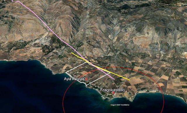
Hood wants these ruins to be 1500 m. from Fragokastello and 'less than' one km. from the coast.  Perhaps we can bound the area of uncertainty by using these constraints.  The next picture shows a white bounding box which covers the area 1500 m. from Fragokastello Castle  (red circle) and a kilometer from the coastline (the yellow line):


Somewhere in here should be the ruins of Ayios Eustratios.  But where?   I wanted more clues so I headed back to Hood who gives a photograph of the apse of a ruined church in the Ayios Eustratios.  It looks like this:


This is a column from the apse of the church of Ayios Eustratios.  The only clue which this picture affords is a snippet of ridge-line behind the church on the left.  If it were possible to locate this ridge line it would be possible, just, to draw a back azimuth that might cross our town.  Is that possible?  First I wanted more detail in the ridge-line.


Well, this looks  pretty bad.  It's not going into our collection of vacation snapshots.  But that's not the point.  I ran this through an HDR processor from NIK software and crunched it to the maximum.  Now it's quite possible to make out more detail in our ridge-line.  However, we still haven't found the snippet of ridge that this shows.

I went back into Google Earth and tried to locate this ridge.  Here it is from Google's ground view:


If you compare the enhanced photo with the ridge shown in the white box you'll see the same section of ridge-line.  Just to be more certain I looked at the same ridge from Google's Street View:


I enhanced the ridge snippet from the Google Street Drive photo and got this:


On the left is Hood's picture and on the right is the enhanced section of ridge from Google's Street View.  I think that this is it.  Now if we can draw a line from that ridge point and at right angles to it, through the bounding box we might better be able to locate our ruins.  Here it is:


In this picture the purple line is drawn from the top of the ridge in the photo at what, frankly, is a guessed angle through the bounding box.  The red circle is radius 1500 m. from Fragokastello Castle.  And the yellow line is about 1 km. from the coast.  All the constraints are met so somewhere, at the NE side?, of the white bounding box we should be able to find the town of Ayios Eustratios.


Here it is in close-up; what's that semi-wooded area at the right corner?


This looks like our town.  Hood says: 

"The site is strewn with abundant stones from buildings, and the ruins of an early Christian basilica church are visible."

I ran this picture through every algorithm I could think of in order to bring out the ruined walls and here they are, unmistakably.   The former walls have the curious 'smeared' appearance of walls that have sat undisturbed for a couple of thousand years.  I am convinced that this is the right place.


Can we now find the church of Ayios Eustratios?


I think that this shows it.  The structure pointed to by the arrow is a little longer than Hood says, about 18  m. vs. his 15.  But the width is right.  I make it to be just a hair more than Hood's 12 meters.


 The real scandal here is how consistently bad Pleiades' data is.  Here's a map which compares my position to theirs.  The length of the red line that joins the two positions is 2122 m. long.  So Pleiades is more than two km. out.  Tell me again why Pleiades' data is used by scholars?


Ayios Eustratios is now in the M.A.P. as C7416.


Notes

[1] Hood [1967] 55,   'B. 7. Ayios Evstratios'.

Bibliography

 Hood [1967]:  Hood, M.S.F.  'Some Ancient Sites in South-West Crete',  The Annual of the British School at Athens, (62) pp. 47-56. 1967.  Online here.  

Monday, January 24, 2022

 Pleiades and Roukouni Korphi


Sometimes I wonder why Pleiades even bothers.  In truth, I wonder that a lot of the time.

Case in point: Pleiades no. 590035 which has the name 'Roukouni Korphi'.  After clicking on this and getting the inevitable annoying zoom-in from outer space we find ourselves staring at a barren landscape somewhere in SE Crete. 

What is Roukouni Korphi?  We are not told. 
Why was it selected for the atlas?  We are not told.
What does it depend on?  We are told that it is digitized from the Barrington Atlas

Well, it turns out that Roukouni Korphi is a circular structure,, perhaps a tower or look-out of some sort that dates from the Hellenistic.  I discovered this long afterwards.  The immediate problem was to find it because Pleiades' coordinates are obviously wrong.

I discovered that the ultimate source for this was in an article by Sinclair Hood who describes it like this:

"(11) ‘Roukouni Korfi’ ('Ρονκούνη Κορφή). Α high peak at the western end of the range of hills
on which (6) ‘Xinakhladha’ and ‘Tourkissa’, (7) ‘Kastellos’, and the sites (8), (9) near it lie,
about five minutes above (7) ‘Kastellos’ to the west. A few metres east of the summit Platon
has excavated an interesting circular building, which appears to be a beacon or guard station
constructed in Late Hellenistic times (Ergon for 1960, 206 f., with plan; cf. BCH lxxxv (1961)
876—7; ΚΚ xiv (1960) 511—12; ADelt xvi ( 1960) 259). This was no doubt in the territory of
ancient BIANNOS (see p. 83), and from the summit there is a very extensive View over the
Mesara plain to the west with Tsoutsouros (ancient INATOS) to the south, and as far as Arkalo—
khori and Mt. Juktas to the north."

So all we have to do is figure out where Xinakhladha, Tourkissa, Kastellos, and sites 8 (Amigdhaloi) and 9 (Bubouli) are located and then we look for a 'high peak' near there. I guess.

I went over Hood's article iwth a fine-toothed comb and I plotted all the points which he and his team describe around Khondros. The result is as you see in the next picture:


This does look like a section of a Jackson Pollock.  In actuality it is the area just above Kastri, NE of Inatos and SW of Biannos in south-eastern Crete.  There are two towns here, Perivolia on the upper right and Chondros on the lower right.  To the W of Chondros there is a valley which is watered by the Chondros stream.  On the S of that stream is a range of rocky hills on the top of which lies Roukouni Korphi (arrow 'Actual' at lower left center).

Here's another view from the north that shows the area in question:


Hood and his team name 11 sites worthy of note in this area of which R.K. is no. 11.  In order to locate it securely I located all 11 as closely as the descriptions permit.  After having done that it was relatively easy to locate R.K.  It is described as " ... about five minutes above (7) 'Kastellos' to the west."  The lat/lon pair for Kastellos is: 35.026222° N, 25.364229° E   When I scanned the peaks just to the W of 'Kastellos' I quickly discovered this: 


This matches the diagram given in Daux [1961].  [2]


Its position is: 35.023444° N, 25.359333° E

So, relative to its true location, where did Pleiades put it?  I measured the distance between the actual location and the Pleiades given location.  It turned out to be 949 m, which is almost exactly the median predicted Pleiades error of 930 m.[3]


Footnotes

[1] Hood, et al. [1964].
[2] Daux [1961] 873.  The description of the site is given on pp. 876-7.
[3] Consoli [2013].


Bibliography

Consoli [2013] : Consoli, Robert,  'A frequently asked question about the Pleiades redesign', Squinches (a Wordpress Blog),  7/24/2013.  Online here.

Daux [1961] : Georges Daux, 'Chronique des fouilles et découvertes archéologiques en Grèce en 1960', Bulletin de Correspondance Hellénique [85], pp. 601 - 953.  1961.  Online here.

Hood et al. [1964] : Hood, Sinclair and Peter Warren , Gerald Cadogan, 'Travels in Crete, 1962', The Annual of the British School at Athens (59), pp. 50-99. 1964.  Online here.

Tuesday, January 18, 2022

Ceramic Horizon Search and Years AD


New Ceramic Horizons search page

The Mycenaean Atlas has a new way to search for date ranges if that's all you want to do.  Right now you can do this from the Control Page drop-down menu for 'Ceramic Horizon'.  I thought that it would be handy to be able to search for time periods by thumbnail, the same way that you can search by region from the thumbnail maps.  So I created such a whole page search just for ceramic horizons.  To the Control Page thumbnail box I added a new thumbnail called 'CHRON'. 

When you click on that thumbnail you'll get the new Chrono search page:


It should be easy to understand this page.  The abbreviations for the various ceramic horizons are standard English abbreviations.  When you click on one the Atlas will return a map page with just the sites on it for that ceramic horizon.  At this point you can generate reports for that ceramic horizon if that's what you want to do.

The page does not cover all date ranges (ceramic horizons).  For the full set you have to go to the drop-down.  There ahould be enough choices on the new ceramic horizon page to make it very useful.

This page does not yet include a number of useful ceramic horizons, specifically 'Cypriot' but I'm going to work on adding those.

Years AD

I've been experimenting with the idea of bringing coverage in the Atlas forward in time from the Bronze Age.  The island of Naxos is a convenient place to start as it is self-contained.  The first of these sites to be added was Irokastro (C7405) which was a stronghold  in the SE part of the island.  

The page for C7405 looks like this:


Adding this site caused breakage to the Atlas because C7405's dates of use span the year 1 AD and the database isn't designed for years in the Christian era.  What to do?  I've defined the R(oman) period as 753 BC to 395 AD. 

  The old time_span DB table has two columns for year ranges: post and ante.  If I just stored R(oman) as post:753 and ante:395 the software would interpret this as R ranging from 753 BC to 395 BC.  Not good.

   This is a fairly vanilla problem in DB design and development and several solutions are possible.  First, as doctors say, do no harm.  The least desirable solution is to perturb what's already there.  In its restricted range of BC the code already works fine.  How will we add in years AD in a non-destructive way?

   One thing that could be done is to assign years BC a minus sign: Make them negative with years AD being positive.  This kind of solution makes me itch and sounds too clever by half.  I don't do any year span calculation in the code but if I did this would be the wrong solution.  

Computing a range of years with the years BC negative would be like this:

$R = $Yante + abs($Ypost) - 1;

So 753 BC to 395 AD is 395 - -753 - 1 = 1147;

Making the years AD negative is still icky and amounts to about the same thing.  Here computing a range of years is just Ypost - Yante - 1.   

So 753 BC to 395 AD is just 753 - -395 - 1 = 1147 (we subtract 1 because there's no year 0).  

I still don't like it.  

   A better solution is to bite the bullet and add a column or two(?) to the DB time_span table which will carry the era information about the era for each year range endpoint.  In this way we separate out the absolute year value from the era it belongs to.  Having done that we can now rely on the software to put these together in whatever way seems suitable at coding time.  What should these extra columns contain?  Well we could have two columns of binary values; one column for post and one for ante.  false (0) could stand for BC and true for AD.  This is the classic computer solution and a lot of people would do this but from my perspective this has a drawback.  

For the two year range endpoints there are only three legitimate values: BC & BC, BC & AD, and AD & AD.   AD & BC (AD followed by BC) is not a valid value.  

Decoupling these two values into two separate columns will not automatically prevent our specifying AD-BC or 1,0.  I want to be protected from my own stupidity.   I finally decided to implement 1 new field with a set of three allowable values: '00', '01', and '11' where 0 represents 'BC' and 1 represents 'AD'.  The DB allows no other values in this field (which I called 'bcad') such as '10'.   I defaulted this field for the whole table to '00'.  I then set the new R record to '01'.

  There remained two places in the SW where changes had to be made: 
a) where I print out the year ranges in the place key report page and 
b) where I pop-up the year ranges on the Chron report page.  

I had to change the query to retrieve the new bcad field for each range and write separate code for each of the new three cases to add on the correct 'BC' or 'AD' suffix before printing out the year range:  In PHP pseufo-code it looks like this:

switch ($bcad)
{
Case '00'  : {$postname = $postname."BC"; $antename = $antename. " BC";  break;}
case '01' : {$postname = $postname. "BC"; $antename = $antename." AD" ; break;}
case '11' : {$postname = $postname. "AD";  $antename = $antename." AD" ; break;}
default : {break;}
}

or ( more cryptic)

$postname = $postname. " BC";   $antename = $antename. " BC";

switch ($bcad)
{
case '01' : { $antename = $antename." AD" ; break;}
case '11' : {$postname = $postname. " AD"; $antename = $antename. " AD"; break;}
default : {break;}
}

The first is what I actually did.  Another solution consists of treating the $bcad values as indexes into an array of suffixes:

$baArray = array( "BC", "AD");

The code is then just:

$postname = $postname." ".$baArray[$bcad[0]];
$antename = $antename." ".$baArray[$bcad[1]];

 O.k. you get the idea.  So on the place key report page you now will see 'BC' for years BC where you never did before and when you look at C7405 you'll see "753 BC - 395 AD" shown correctly:


 This also goes for the tooltips on the chronology page.  I hope that's the last correction I have to make to support dates 'AD'.

Monday, November 29, 2021

Some Preliminary Thoughts. Mycenaean Atlas Project


Some preliminary thoughts and readings:

- FINDING ROMIRI: 

Without using the Mycenaean Atlas specifically see if you can find 'Romiri'.

  • 1. Messenia II, McDonald and Simpson, p. 233, no. 37B  Avisos (Romiri).   Online here.
  • 2. Mycenaean Greece, Richard Hope Simpson [1981], p. 120, 'F38 Romiri: Avisos'.  Online here

The answer is here.  No peeking.

     I myself cannot find the spring 'Kephalovrisi'.  Can you?

McDonald and Simpson [1964] 233 say that from the site to the Chapel of Analipsis is 186 degrees; to the mountain of Chandrinou (Hagios Elias) is 267 degrees; and from the site to the center of Mesopotamos village is 338 degrees.  So the back azimuth from these three sites is 6, 87, and 158 degrees respectively.

  • Chapel of Analipsis: 186     6 degrees backwards from chapel
  • Mountain of Chandrinou: 267       87 degrees backwards from mountain
  • Mesopotamos Village (center): 338        158 degrees backwards from Mesopotamos

- Moral for Finding Romiri

Obsolete names become embedded in the archaeological literature as here in Romiri (many abandoned towns), on Antiparos (Krassades: C7134), and elsewhere (Elis).  This is a powerful incentive to map as many of these sites as possible so that the knowledge is not lost and does not become an esoterica.


- Some Blog Posts

- Some Slides:

Locating C390 (Gargaliano Megas)

- Follow the telephone wires ...     Tracing phone wires to locate a site.  Here C390 (see slide)


- Here is an example of one way to locate a site.   The  site of Gargaliano Megas (C390) is described in Davis and Bennet's Pylos Regional Archaeological Project.  The landscape is gently rolling low hills covered with brush and monocrop olive culture.  It is difficult to find by just using a map.  The one photograph shows poles with electrical wires.  It was possible in this instance to start by tracing the visible wire network in Google Earth and then matching that network's likely locations to the photograph.  Once that was done it was possible to re-create the original photograph in Google Earth and confirm the actual site location (top of the hill in the middle distance).   More than that it was possible to locate the position and the angle from which the photograph was taken.  Recreation of photos in Google Earth is a powerful technique.


DB Input Forms


Many tools and utilities can be written to make the creation of such a database simpler.  Putting 4000+ records into a database is no trivial task for a team member.  This process can be shortened and made reliable by creating DB input forms.  Here's an example of one of those forms which fills in the main table.  On the left is the form itself and on the right is the resulting MySQL code which goes to the DB.  Using such forms reduces errors and saves time.   It just looks like a form.  When it's filled in the submit button sends the input to a PHP program that generates the corresponding MySQL statements.  It's often worth the cost to write database input tools.    


What sorts of numbers are required for accurate site location?


A primary goal of the DB was accuracy of location.  Analytical tools will only work properly when the input data is accurate and I made a commitment to expend every effort to achieve that goal.  Of course many of these sites are not clearly locatable.  The control page allows you to survey various levels of accuracy.

What about the Bronze Age Collapse?


The M.A.P. wasn't created in order to support any particular theory.  Nonetheless it's remarkable that it appears to show signs of something catastrophic occurring at the end of the LHIIIB.   Here are two images; the left shows what a search for 'Settlement' looks like in Messenia for the LHIIIB.  The right-hand slide shows the same thing during the LHIIIC.

You can generate .kml or .csv files of such searches


- What Effect, if any, does such an Atlas have on Site Security?  Should the M.A.P. be taken down?  Discuss.

  • - Some scholars think that lat/lon pairs should be published.
  • - Most sites were discovered forty years ago or more and published long ago.
  • - Who is robbing sites?  Do they do research on the Internet to find sites?
  • - In the age of Google many sites can be seen from aerial photographs.
  • - I actually don't publish everything I know about.  Currently I'm sitting on a large number of sites that I have been asked not to publish

- Suggestions for further work:

We need an up-to-date map of the finds around Koukounara/Gouvalara (C333) in Messenia (or at least I need one.)  See #Things_Mycenologists_Say, fn. 11.


Tuesday, November 9, 2021

Buzzword Bingo: How to speak 'Pleiadese'

                 ἢ τίς ἐστιν ἐξ ὑμῶν ἄνθρωπος,
                 ὃν αἰτήσει ὁ υἱὸς αὐτοῦ ἄρτον, μὴ λίθον ἐπιδώσει αὐτῷ;
    "Or what man is there among you who, if his son asks for bread, will give him a stone?"

    Matthew 7:9


    Like most of you I'm a huge fan of the papers and websites that come out of the Pleiades/ Pelagios/Peripleo/Recogito workshop.  It turns out though that a lot of the vocabulary that they use is from the world of Computer Science and not from the Humanities.  The Pleiades Team has never met a computer buzz word that they didn't fall madly in love with and so their writings can be ... abstruse ... and require a lot of interpretation before you can figure out what the heck they're saying.  The result is that many of you want to know more about this software effort but can't get past the vocabulary.  

    How about a nice dictionary of all these buzzwords which would help you not only to understand what PT is on about but will have the potential to lift your own writing to a whole new level of buzz-worthiness?

    Well, I've got your back. 

    This post is a vocabulary list of some of the PT's favorite buzzwords.  I've arranged them alphabetically (more or less).  In my next post I'll begin the work of relating these terms to each other and putting them into a clear context. 

    I hope that you'll play along by submitting other buzz words from their writings which I may have missed and that you will suggest corrections.  And don't let the number of terms worry you.  Like all buzz words, most of them mean exactly the same thing.  

    Some of these entries refer to articles in Wikipedia.  I know, I know.  However Wiki often deals with technical topics in clear and precise terms and that's why I used it in these instances. In a post after this I'm going to try to tell the Pleiades story in terms that everyone can understand and which will show how these vocabulary items can be understood in the Pleiades context.

    A * before a word means that it's defined elsewhere in the list.

    Term
    Definition
    Sources
    ARCHESThis is the Getty sponsored *ontology.
    PGPP0002;
    ARCHES is described here.
    CIDOCAn *ontology.  An instance of a *Conceptual Reference Model (CIDOC CRM).  "The CIDOC Conceptual Reference Model (CRM) provides definitions and a formal structure for describing the implicit and explicit concepts and relationships used in cultural heritage documentation...to promote a shared understanding of cultural heritage information by providing a common and extensible semantic framework that any cultural heritage information can be mapped to."PGPP0002; Wikipedia provides more here.
    conceptual reference model  (CRM)A theoretical *ontology.  A controlled vocabulary with variations for many areas of professional work.  Here, in particular, the area of cultural heritage.Described by Wiki here.
    contextualisationHere it means lots of different people's data/projects hooking up to the same geographical network of nodes which  provides the context.
    CRM
    An *ontology.

    *conceptual reference model
    https://www.igi-global.com/dictionary/conceptual-reference-model-crm/5242
    decentralise,

    decentralization
    decentralise here means 'other people do the work and then attach it to our backbone.'
    From PGPP0002 (Abstract) 

    "This paper discusses an emerging cloud of Linked Open Data in the humanities sometimes referred to as the Graph of Ancient World Data (GAWD). It provides historical background to the domain, before going on to describe the open and decentralised characteristics which have partially characterised its development."
    discoveryHere it means 'You'll have more hits to your project if you attach it to our backbone.'   No numbers are presented.PGPP0002: " ..., as well as the increased likelihood of discovery by consumers following the same API in the opposite direction."
    Dublin Core"The Dublin Core™ Metadata Element Set is a vocabulary of fifteen properties for use in resource description."PGPP0009; Their homepage is here.
    emic concepts"emic concepts, i.e. those which originated in the languages of those periods."PGPP0002
    etic concepts"etic conceptual schemes developed by contemporary scholars to describe cultural phenomena for which no linguistic evidence survives."PGPP0002
    GAWDGraph of Ancient World Data
    R. Robineau. Graph of Ancient World Data, June 2012.  See an explanatory diagram here.

    GeoNames
    An enormous DB of geographical names which can be used as the basis for a standardized naming system which, i fit were adopted in Humanities research, all researchers would have to conform.


    "The GeoNames geographical database covers all countries and contains over eleven million placenames that are available for download free of charge."
    Their primary web page is here.
    graph databaseA database that supports the establishment and modification of data that is envisaged as a collection of linked nodes.

    A paper by Pokorný is here. 

    Pokorný makes the important point that graph structures can be represented by relational DBs.

    "For example, we can represent a graph by tables in a relational DBMS (RDBMS) and use sophisticated constructs of SQL or Datalog to express some graph queries."
    interconnection format
    PGPP0001, This term deprecated and now replaced by the *Linked Places Format
    ISAWInstitute for the Study of the Ancient WorldPGPP0002; Homepage is here.
    ISO, NISO
    International Standards Organization,

    National Information Standards Organization
    This is ominous to me.   Real scholarship has no business whatsoever being anywhere near any Standards Organization. 


    The NISO (founded in 1939) is described here and it is hand-in-glove with the International Standards Organization or ISO.  I should think that ISO wouldn't, for shame, be able to hold up its head after the disasters of the 80's and 90's.
    JiscA UK Funding body.  They provide 'digital solutions'.  God only knows what they actually do.PGPP0002; Their website is here.
    Linked Ancient World Data Institute  (LAWDI)A workshop held in 2012.  " ... the Linked Ancient World Data Institute (LAWDI), an internationally attended workshop funded by the National endowment for humanities' office of Digital humanities ... "  It was hosted by ISAW and Drew University.

    More information from the National Industrial Standards Organization (NISO) here.  This seems alarming to me.  What relevance could the NISO have to scholarship?

    LAWDI is dealt with by National Endowment for the Humanities here.
    Linked DataA structure consisting of virtual nodes of information each one of which has a connection to one or more others or is connected to by one or more others.I don't think too much harm can be caused by linking to Wikipedia in this instance.
    Linked Open DataFrom the Getty document : "When data is linked and open, it means that data is structured and published according to the principles of Linked Data, so that it can be both interlinked and made openly accessible and shareable on the Semantic Web."
    PGPP0002;  e.g. the Getty's LOD which is described here.
    These are  the documents which relate the Getty Institute vocabularies to an actual data linking standard.
    Linked Places Format
    A regimented name list:

    "Linked Places format is used to describe attestations of places in a standard way, primarily for linking gazetteer datasets."

    "LPF v1.2 is implemented in current versions of World Historical Gazetteer and Pelagios projects, including Recogito."
    Defined here.
    LinksA convention by which one entity may refer to another.
    PGPP0001
    "The purpose of the place records is to form anchor points for cross-linking between  different gazetteer datasets (no more, no less) in order to indicate similarity."   and  "defined as a relation “[...] used to link two concepts that are sufficiently similar that they can be used interchangeably in some  information retrieval applications”
    mereologicalThe study of the relationship of part to part or parts to a whole
    PGPP0002;  Defined here.

    I have to confess that this buzzword was my hands-down favorite.
    meta-Tags which are added to the semantic web in order to, among other things, establish the authoritative document from which the semantic node is derived.The main difficulty with the Semantic Web is that there is no built-in provision for sourcing subject or object nodes and no way to prevent different triples in the same system from being contradictory.  'Metatags' are layered on to try to correct this problem.  The resulting complexity which tags introduce often leads to the collapse of the system.
    namespaceHere:   A specific closed set (only these names are allowable for members that are formally connected to the specific namespace).This is also a concept in Anthropology where certain societies draw from a bounded set of names as the only proper names for their members.  See Harrison [1990].
    NEO4jA db tool that creates graph databases where the link is automatically stored with the node.  This product is orders of magnitude more powerful than anything Pleiades could ever conceivably require.

    There is a 1 minute video here which gets right to the (simple) nitty-gritty. 
    ontologyIn this instance: A formalism for defining object names and definitions unambiguously.  E.gg. CIDOC and Open Annotation.  Also the Getty ARCHES system.  The intent is usually to create an exhaustive *namespace for the primary entities in the Domain of Discourse.Really a 'cosmology'.  See the remarks in Cramer [2007].  [1]
    Open Annotation" ... an interoperable framework for creating associations between related resources, annotations, ... "
    PGPP0002; 

    More here.
    Open Annotation OntologyAn open annotation formalism that deals with objects.Online here.
    PDDLAn Open Data LicensePGPP0002
    RDF
    Resource Description Framework

    An RDF is a formalism that describes how triples should wear fancy dress.  See *serialization.

    From Ontotext website:
    "RDF is a standard for data interchange that is used for representing highly interconnected data. Each RDF statement is a three-part structure consisting of resources where every resource is identified by a URI."

    From the W3C wiki:  "RDF extends the linking structure of the Web to use URIs to name the relationship between things as well as the two ends of the link (this is usually referred to as a “triple”)."
    RDF dealt with clearly on the Ontotext website here.
    RDF-based *serialization format*Serialization based on RDF triples.
    PGPP0001;
    For a discussion of the advantages and disadvantages of various *serialization techniques see this.
    RecogitoA note-taking applicationHomepage is here.
    RESTRepresentational State Transfer.  A set of 'best practices' for programming on the Internet.  Makes use of the ideas of *URIs, etc.
    PGPP0009
    https://en.wikipedia.org/wiki/Representational_state_transfer

    https://shareurcodes.com/blog/creating%20a%20simple%20rest%20api%20in%20php
    RESTful"A web API that obeys the *REST constraints is informally described as RESTful."  God help us.https://en.wikipedia.org/wiki/Representational_state_transfer
    RFCRequest for Comments.  A document which specifies a  protocol or specific form or procedure for accomplishing something.
    SemanticIn all cases under consideration this refers to 'meaning'.  That is (the machine) understanding and reacting as though Athens is a real place as opposed to understanding 'Athens' as a coded token only.   That machines cannot interpret anything in terms of semantics is what drives 99% of everything being discussed here.
    Semantic WebA computer structure optimistically thought to embody *semantic meaning but really only interlinked computer tokens.  *linked dataSee this on Wiki.
    SeneschalSemantic ENrichment Enabling Sustainability of arCHAeological Links.  Vocabularies and tools aimed at homogenization of terminology in the field of Archaeology.  Although portions of it have been re-used the project itself seems defunct.PGPP0002;  Home page for Seneschal is here.
    serialization, serialization format
    A formal representation of RDF triples.  There are several ways that this is customarily done: e.gg.,   XML, RDFa, .n3, Turtle, N-Triples, N-Quads, JSON-LD, JSON-AD, HexTuples, HDT, RDF Binary Thrift. 
    After you form ('write down') your RDF triples then you'll have to 'serialize' them or convert them into some computer formalism meant to support triples.
    For a discussion of the advantages and disadvantages of various serialization techniques see this.
    Shared backboneThe use of a single reference gazetteer to which all the others must link : "to choose a single “reference gazetteer” (or a small number of them) to which every specialist gazetteer should strive to link."    " ... and are available as Linked Data."PGPP0001
    skosSimple Knowledge Organization System.  An *ontology.PGPP0001; Home page for SKOS is here.
    SNAPStandards for Networking Ancient Prosopographies
    Home page is here.


    stakeholdersParticipants and contributors to a project.PGPP0002
    TEIText Encoding Initiative;  A text markup formalism.  On their site: "a consortium which collectively develops and maintains a standard for the representation of texts in digital form."https://tei-c.org/
    triplethree entities although here: two objects connected by a link"A semantic triple, or RDF triple or simply triple, is the atomic data entity in the Resource Description Framework data model. As its name indicates, a triple is a set of three entities that codifies a statement about semantic data in the form of subject–predicate–object expressions". More in Wikipedia
    Turtle (RDF)
    A formalism for expressing an entity in a linked data system.
    http://snapdrgn.net/about)
    A sample definition (for Athens) is in PGPP0001 in Figure 8.5.
    URCUniversal Resource Characteristics
    A helpful blog entry that explains URI, URN, URL is here.

    This Venn Diagram shows the relationship between URL, URN, and URI.
    URIUniversal Resource Identifier.  An identifier of a specific resource,  e.gg. page, book, document.  Does not necessarily contain the means or address for accessing it.  See: PGPP0001  Also PGPP0002 : "the establishment of services providing stable URIs for shared categorical and instance thesauri."
    PGPP0002

    This Venn Diagram shows the relationship between URL, URN, and URI.
    URNUniform Resource Name: A URI that uses the URN scheme.  "persistent, location-independent identifiers assigned within defined namespaces, typically by an authority responsible for the namespace, so that they are globally unique and persistent over long periods of time"
    For more on URNs see the wiki article here.

    This Venn Diagram shows the relationship between URL, URN, and URI.
    Upper Ontology"In information science, an upper ontology (also known as a top-level ontology, upper model, or foundation ontology) is an ontology (in the sense used in information science) which consists of very general terms (such as "object", "property", "relation") that are common across all domains."https://en.wikipedia.org/wiki/Upper_ontology
    URLUniform Resource Locator.  All URLs are URIs but not all URIs are URLs. (A subset of URIs)   "special type of identifier that also tells you how to access it, such as HTTPs, FTP, etc.—like https://www.google.com." 
    A helpful blog entry that explains URI, URN, URL is here.
    This Venn Diagram shows the relationship between URL, URN, and URI.

    Vocabulary (controlled Vocabulary)Lists of standardized and homogenized terms for every aspect of the Humanities to which researchers will be forced to conform.PGPP0002 : "Controlled vocabularies   An extremely important development has been the establishment of services providing stable URIs for shared categorical and instance thesauri.  These include place gazetteers, type classifications for coins and canonical citations for classical literature.  Without them, earlier attempts at 'interoperability' were seriously hampered by the lack of common reference terms for analogous content despite the availability of ontologies that defined shared or equivalent properties."

    Footnotes

    [1] Cramer [2007] :  " ... what he and computer science  call "ontology" is, outside such jargon and in a more common sense  language, not an ontology, but a cosmology."  'He' is Tim Berners-Lee.


    Bibliography

    Berman et al. [2016] : Berman, Merrick Lex and Ruth Mostern, Humphrey Southall eds. Placing Names: Enriching and Integrating Gazetteers. Bloomington: Indiana University Press, pp. 97–109. 2016.

    Cramer [2007] :  Cramer, Florian.  'Animals that Belong to the Emperor',  Online here.

    PGPP0001 :  Simon, Rainer and Leif Isaksen, Elton Barker, Pau de Soto Cañamares, '8. The Pleiades Gazetteer and the Pelagios Project' in Berman et al. [2016], pp. 97-109.  Online here.

    PGPP0002 :  Isaksen, Leif and Elton Barker, Rainer Simon, Pau de Soto, 'Pelagios and the emerging graph of ancient world data', June 2014.  DOI: 10.1145/2615569.2615693.  Online here.

    PGPP0003 :  Barker, Elton, and Anna Foka, Kyriaki Konstantinidou, 'Coding for the Many, Transforming Knowledge for All: Annotating Digital Documents', Publications of the Modern Language Association, 135(1) pp. 195–202.  2020.  Online here.
                    RGPP0009 : Elliott, Tom and Sean Gillies.  'Digital Geography and Classics', 
                  Digital Humanities Quarterly(3:1) 2009.  Online here.

                 Harrison [1990] :  Harrison, Simon.  Stealing People's Names, Cambridge University Press, 1990.


Blog Posts Concerning the Isthmian Wall

Since 2023 a number of posts concerning the Isthmian Wall and how we located its remaining segments, have appeared on this blog.  This post ...