Sunday, January 22, 2017

Introduction to the Mycenaean Atlas Project, Part II


Part I of the Introduction to the Mycenaean Atlas Project may be found here.

f. PERIODS: Under this heading I include basic information about the periods of occupation of each site. I include here the sources which identified these periods along with, usually, a brief quotation from the source which justifies my including the specific period in the specific site article.


g. GENERAL: In many cases I include a brief statement that specifies why I have placed the specific site marker where I have. Ordinarily, when the site is marked ‘N’ or ‘unknown’ I include here a remark about the special difficulties encountered in finding the correct location. This is in the hope that others may start where I have left off and, perhaps, have a better start locating the desired place.


h. BIBLIO: This lists the sources that I found of especial value in identifying this specific site location.


CONCORDANCES

This document provides concordances between my pk numbers and the various numbering systems adopted by those gazetteers upon which I relied most heavily.
In this version I include concordances for the following:

1.   French [1967],     French, D.H.   Index of prehistoric sites in central Macedonia and catalogue of sherd material in the University of Thessaloniki, Athens, 1967.

This was done in part as I encountered references to French in Simpson [1981].

2.   Heath [nd],     Heath, Sebastian.  PRAP Site Gazetteer

This is the website of the Pylos Regional Archaeological Project. The concordance contains those sites with periods given as ‘EH’, ‘MH’, or ‘LH’.
   
3.   Jameson et al. [1994],     Jameson, Michael H, Curtis N. Runnels, Tjeerd H. van Andel, A Greek Countryside; The Southern Argolid from Prehistory to the Present Day, Stanford University Press, Stanford, California.  1994.  978-0804716086

In the concordance are sites which Jameson et al. identified as ‘EH’, ‘MH’, or ‘LH’.

4.   McDonald and Rapp [1972],     McDonald, William A. and George R. Rapp, Jr., The Minnesota Messenia Expedition: Reconstructing a Bronze Age Regional Environment, University of Minnesota Press, Minneapolis, Minnesota.  USA. 1972.

The concordance contains all the sites in Register A beginning on p. 266.

5.   Pelon [1976],     Pelon, Olivier.  Tholoi, tumuli et cercles funéraires; Recherches sur les monuments funéraires de plan circulaire dan l'Égée de l'Âge du Bronze (IIIe at IIe millénaires av. J.-C).  Bibliothèques de l'École française d'Athènes et de Rome - Série Athènes, 229. 1976.   

6.   Simpson [1981],     Simpson, Richard Hope. Mycenaean Greece. Park Ridge, New Jersey: Noyes Press, 1981. 

7.   Simpson [2014],     Simpson, Richard Hope. Mycenaean Messenia and the Kingdom of Pylos. Philadelphia:Instap Academic Press, 2014.  978-1-931534-75-8.

8.   Simpson and Dickinson [1979],     Simpson, Richard Hope and O.T.P.K. Dickinson,  A Gazetteer of Aegean Civilization in the Bronze Age, Vol. I: The Mainland and the Islands, Paul Astroms Forlag, Goteborg. 1979.

    The material in this gazetteer is substantially repeated, often word for word, in Simpson [1981].  As a result only a few citations from this work are currently in the database.  Adding the entire work is planned for the future.


RELEASABLE FORMATS

This current document is meant purely to furnish an on-line resource of the contents of the locational database.  It is probably best used with a search facility.  

 A version of this document in .pdf format is available to be sent to any requester.
The specific aim of this database effort is to supply the interested user with a dynamic and interactive environment for exploring the Mycenaean world.  So, for those interested, there are available .kml files of the DB.  A basic .kml already exists of all the Mycenaean find spots.  It merely needs to be imported into Google Earth.  A tutorial describing how a Google Earth import is done is here.


 The entire database can be furnished as a .sql file to whoever may be interested, professional or amateur, simply by sending an e-mail here: 

bobconsoli@gmail.com

As a .sql it can be imported to any environment hosting a SQL server such as MySQL.  MySQL is a free, industry-standard implementation of a SQL server and is used very widely, for example, in internet applications. 

The Mycenaean Atlas Project itself has, at present, no internet component.

FUTURE PLANS FOR THE DATABASE

At this time the database is weakest with respect to Crete, Cyprus, and Italy.  Those places will be filled out in more detail in the future.  New releases of the database will be announced here:

mycenaeanatlasproject.blogspot.com

I welcome better locational information from those who have actually been to any of these sites.  I know that there are many individuals who can assist me in driving accuracy parameters to 0 and any contribution will be credited to the sender.

This project is entirely my own and any errors in it are mine. 

Blog posts on topics relating to the Mycenaean Atlas Project and other writings about Mycenology may be found at my two blogs:

mycenaeanatlasproject.blogspot.com

and

squinchpix.blogspot.com


Part I of this introduction may be found here.


BIBLIOGRAPHY

Papadopoulos [1979]: Papadopoulos, Thanasis J., Mycenaean Achaea; Part 1: Text.  Paul Aströms Förlag, Göteborg, Sweden. 1979. Vol 1.  ISBN: 91-85058-83-1

Tsakirakis [2000]: Tsakirakis, Vangelis G. "Using a Relational Database Management System for the Recording of Ancient Settlements and Sites in the Vrachneika Territory in Western Greece\", Online Proceedings of the group: Computer Applications & Quantitative Methods in Archaeology, 2000. http://proceedings.caaconference.org/year/2000/');


Friday, January 20, 2017

Introduction to the Mycenaean Atlas Project, Part I

INTRODUCTION


The purpose of this document is to provide accurate latitude/longitude pairs for every identifiable site associated with the Mycenaean people. There are several important reasons for doing this.


1. There is a need. There have been smaller scale projects in the past which have attempted to map portions of the Mycenaean Cultural Area. For example there is the Archaeological Atlas of Mycenae co-authored by Spyros Iakovides and E.B. French. Another computer survey project that I am aware of is that of Vangelis Tsakirakis.[1]  Dr. Tsakirakis is, or was, associated with the Landscape Archaeology Group. Dr. Tsakirakis and his team implemented an ambitious database of historical information about Achaea. Among other sources it relied on the work of T.J. Papadopoulos so that LAG’s intention was, at least in part, to map Mycenaean sites.[2]  Regrettably it appears that their web site is no longer functional and I can learn nothing more about the status of their project.

2. The older gazetteers, upon which generations of Mycenologists have relied, are gradually becoming unusable due to the changes on the ground in continental Greece and other locations around the Mediterranean. These changes affect not only BA sites but ‘modern’ constructions such as churches, roads or even towns which have been supplanted, destroyed, or modified out of recognition.

3. Destruction of Mycenaean and other Bronze Age sites. There are many reasons for this destruction.  Some of it is deliberate as when farmers destroy sites in order to prevent land from being sequestered by the authorities for archaeological research. Sometimes stone structures are destroyed in order to reuse the material in building projects. And much destruction is inadvertent. Mechanized plowing will do an admirable job of destroying sites if allowed to go on long enough.

4. The destruction of the Greek countryside in general through the practice of plowing the hills into terraces for olive culture. Those who have not been to Greece do not often realize the extent of this devastation.

In former times sites were described by Mycenologists and archaeologists in only the most general terms. Exact locations were only disclosed to other professionals on a ‘need to know’ basis. This simple attempt at ‘site security’ was in response to the relatively common looting of tombs by people looking for ‘buried treasures’ (and, to be sure, sometimes finding them.) It is not the purpose of this document to minimize the problem of site looting. The perspective taken here is that this particular problem is the least of a professional Mycenologist’s worries and that the wholesale destruction of the land itself is a far more serious threat. The first step in protecting a resource is to identify its location. As long as the Mycenological community does not know where many of its foundational sites actually lie no steps can be taken to prevent their destruction. It is high time for full disclosure of these exact locations.

This document contains the exact locations for nearly 1600 reported find spots which have Mycenaean connections. These locations were identified from various gazetteers the most important of which was Simpson [1981]. Concordances to the best represented gazetteers will be found at the end of the document. Of course many other sources were consulted besides the gazetteers. Their names will be found in the Bibliography.

Layout of each entry

I will use PK = ‘C100’ as an example of this document’s method.

a. PK. The pk (‘place key’) number is the unique identifier for the specific site. Here pk = ‘C100’. This series starts with C100 and increases by one for every additional site. Other than identifying the site the pk numbers mean nothing and nothing additional can be inferred from them. They do not, for example, ‘cluster’. Close-by sites do not necessarily have similar pk numbers. Nor are they necessarily consecutive.

The ‘C’ in the pk number stands for ‘Catalog’. A more elaborate justification for a new numbering convention for Mycenaean sites along with a description of the ‘place key’ parameter may be found here.

b. TITLE: This is a string value that serves to provide a pronounceable name for the site. They are not necessarily distinct. They ordinarily identify a nearby place along with some identifier that tells what sort of find this is. None of this is guaranteed. It is the PK number that uniquely identifies the site. For C100 the title is ‘Platanos/Svina: Hab’.

c. POSITION: This is the raison d’etre for the document. Positions are described as lat/lon pairs in both decimal degrees and in degree-minute-second notation.

The numbers that are used for this purpose have a precision of one one-millionth of a degree or six decimal places (k•10E-6).

For our present purposes I will say that the theoretical precision of a lat/lon pair expressed as a floating-point number with six decimal places (k•10E-6) is approximately 11.17 cm. (~4.4 inches) in longitude and a bit less in latitude at 37° N latitude (a typical latitude for Greece).

Although Google Earth provides lat/lon pairs with a precision of 11.1 cm, the actual accuracy of these pairs (for reasons which are not Google’s fault) is closer to 5 m.

An example of how these various positions were derived along with a discussion of the concepts of accuracy versus precision in the lat/lon pairs of the Mycenaean Atlas Project are discussed here.

Establishing accurate numbers, as opposed to precise ones, in Google Earth is a much-discussed subject. The interested reader might start here.

d. ACCURACY: The accuracy parameter has nothing to do with Google Earth. It attempts to state the author’s own perceived accuracy in finding the stated site. This accuracy parameter is imagined as the radius of a circle such that, if the investigator were standing exactly at the given position, a circle of that radius would touch or cover part of the site being sought. Here C100 is thought to be accurate to within 20 m. Again, the web site mentioned just above will give a practical example of how my personal accuracy parameter is ordinarily established.

If the site cannot be precisely located then a lat/lon pair is still given and its accuracy parameter is marked ‘N’ or ‘unknown’. Even though a site cannot be located with confidence it may be that others will make the attempt and that the lat/lon pair given here may furnish a starting point. The numbers of sites at various accuracies are in the following table:


                                                          Error (m)
no. of sites
%
0
542
34.28
10
23
1.45
20
255
16.12
30
1
0.06
50
211
13.34
100
213
13.47
200
113
7.14
300
13
0.82
500
65
4.11
1000
19
1.2
2000
1
0.06
Unknown
125
7.9


e. TYPE: This is a one-word description of the nature of the site. C100 is identified by Hope-Simpson as a habitation. In 'Messenia I' McDonald and Simpson called out the head of a clay figurine and so this is also typed as ‘Artifact’. It is not the purpose of this document to provide detailed analysis about the nature and significance of the site or its date of use. The sources I have specified under each article will do that in far more detail. I include enough material about the Type of site in order to characterize it in general terms for the reader.


[1] Tsakirakis [2000]
[2] Papadopoulos [1979]


Part II of the Introduction to the Mycenaean Atlas Project may be found here.

Saturday, January 7, 2017

Accuracy vs. Precision in the M.A.P.


"You're traveling through another dimension, 
a dimension not only of sight and sound but of mind. 
A journey into a wondrous land whose boundaries 
are that of imagination. That's the signpost up 
ahead - your next stop, the Twilight Zone."
Rod Serling


In a recent post I talked a little about how precise ideal lat/lon pairs are.  One thing I said was that a measurement to one one-millionth of a degree resolves to about four inches in latitude and longitude (4.4 in. in latitude equals 11.176 cm).  Any system that provides measurements like that is said to have a precision of one one millionth of a degree.   In that discussion I ignored the difference between accuracy and precision.  The lat/Lon pairs I provide from Google Earth have a precision of one one-millionth of a degree.  But there’s the additional question of Google’s accuracy.  Imagine that Google Earth was a giant machine for producing lat/lon pairs.   How accurate are those pairs when they come out of the machine? How close do these pairs come to an idealized model of the earth?  Do Google's numbers accuracy match their precision of representation? No.  It appears that they don't.

This is the same as asking how well Google has fitted its source photography to an ideal representation of the earth.  Do the photographs match the ideal grid of the earth itself?  This is a question worth asking because many operations have to be performed on the aerial photography before it’s presented on-line.

For a brief tour of orthorectification issues see this. In this study the authors checked how well Google's lat/lon pairs matched up with lat/lon pairs from a verified data set. The whole article is worth reading. Their conclusion?

"Using accurate field and photogrammetric measurements (extracted from a cadastral database) as the reference dataset and comparing them against well-defined and inferred locations (CPs) in GE’s medium and high resolution imagery, the estimated horizontal positional accuracy of GE’s imagery over rural areas (5.0 m RMSEr) was found to meet the horizontal accuracy requirements of the ASPRS (1990) for the production of “Class 1” 1:20,000 maps. "[1]

The RMSEr is an estimator of the standard deviation based on model results.  So you could, as a rule of thumb, think of 5 m. as the standard deviation of Google's modeling error.  This would mean that 68% of the time the Google lat/lon pair is within 5 m. of the actual position of the sought-after object and about 32% of the time it's further away than 5 m.

But the authors also add some cautions:

"However, the results also suggest that this accuracy requirement might not be met for rural areas if coordinates are extracted only from GE’s medium resolution imagery or from imagery collected before 2008. Furthermore, despite the results presented here, GE’s imagery should be used with caution due to the presence of large georegistration errors in both GE’s medium and high resolution imagery."[2]

In other words we are being warned against actual positioning and alignment errors in Google Earth's images. This can be easily seen if you pick a specific feature on an image and then drop a marker on it for each of Google's available images at that location. Let's look at an example. Here we have a church in Messenia called the Panagia (37.033444°, 21.737154°). If you look into the field across the road you see a circular field feature (I think that it's a well).


I brought up the 'Show historical imagery' slider and marked that well on each layer. The result was this:

Positions of a field feature based on four different available images in Google Earth
Here we see that the field feature (along with everything else) appears to drift and to appear to be associated to different lat/lon pairs depending on the date. The radius of the circle which includes them all is 11.32 meters. So, there's some surprising drift in Google's image alignments. Not fatal but something to take account of.


And just to emphasize what's going on I also show just the image from the May 20, 2003 plate:

Here the entire image has 'drifted' under the markers (which are fixed) until the
5/20/2003 marker is over the field feature.  Notice the displacement of the 'Panagia' label
which should be over the right-side building on the upper left.  This label is displaced nearly
22 m. from where it started.


So there are several potential sources of error in my DB lat/lon.  The first is the degree of Google’s fidelity to an underlying model of the earth's surface, the second consists of Google's alignment of its images. I should just wrap this up by saying that even though GE provides measurements with a precision of 10^(-6) or one one-millionth of a degree (i.e. about 4 inches) the accuracy it provides is, perhaps, a little better than 10⌃(-4) or one ten-thousandth of a degree which at 37 degrees north latitude is about 353 inches (8.96 meters). And this does not take into account imagery offsets.

The third kind of error is the error I introduce when I choose a lat/lon pair to represent a gazetteer entry.

For my general concept of my own 'Introduced' error let's say that we were looking for the field feature mentioned above (the well) and I had only this (entirely made-up) written description as to its whereabouts:

"The church of the Panagia is a kilometer or so to the northeast of the town of Myrsinochori. About 20 or 30 m. to the east of the driveway leading to the church there is a field feature which consists of a stone circle. It is about 10 m. south of the road ..."

Now, given that I could find the Church of the Panagia at all (it is 1200+ m. in a straight line from the northeast edge of Myrsinochori to the church and nearer 1500 m. by road) I would proceed to follow the directions and mark my field feature in good faith like this (I'm pretending that I can't actually see the feature in GE):


In this map the 'H Line' is 25 m. in length (halfway between 'twenty or thirty' meters).  The 'V Line' is 10 m. in length.  After having drawn both those lines (and, I emphasize, based on the written description) I would put a marker at the S end of the vertical line and advertise the lat/lon pair of that push pin as the location of the sought-for feature.  If I had really proceeded like this I might very well feel that my mark was within ten meters of the real feature.  And I would associate my lat/lon pair (at the yellow push-pin) with an introduced error term of ten meters.  In this case I drew a circle with a ten meter radius centered at the push pin.  This circle does, indeed, touch the field feature I'm trying to mark. 

This introduced error term is intended to reflect how well I think I’ve located the object of interest.  I have defined this error term as the radius of a circle, in meters, centered exactly at my lat/lon pair and which covers some part of the sought-for feature.   For example, if the feature can actually be seen in GE then I mark the feature and set the error term to zero.  In that case the "real" error is reduced simply to Google’s accuracy at that point. Given that the features are of various types a non-zero introduced error radius has several possible meanings.  If my introduced error term is ten then, finding yourself exactly at my lat Lon pair means that you are distant from the object by, at most, 10 meters plus Google’s error.  If Google’s error term is 5 meters then, in the worst case, you are fifteen meters away from the goal.  At best the two errors would offset and you would be 5 meters from your goal.

If I can’t see the feature but the description is constrained in some way, a cave opening or a narrow hill- or ridge-top, then I set the introduced error radius to 10, 20, or perhaps even fifty meters.  When the directions available to me are imprecise but I know generally where the feature “ought to be” then I’ll set the error radius to one hundred or two hundred meters. A feature on a "hill-side" would be the classic example.  Sometimes directions to a small site or find are described as being in a certain town.  In such a case, and with no additional info, I will put a marker on the town but set the error term to ‘N’ or ‘unknown’.   I hope it's clear, from the foregoing, that these introduced error radii are subjective only.  They are merely my opinion about how well I did after taking everything into account.  Of course, they’re not fixed in stone, either.  If I rethink an area or if I receive more accurate information from someone who’s been there then the error term can be driven to zero.  In that sense they’re simply a progress report of accuracy; ultimately my introduced error radii should all be driven to 0.

Remember that even small introduced error radii can specify very large areas.  An error radius of ten meters describes a circle with an area of 314 square meters or 3379.0 square feet which is about half the size of the average house lot.  In my DB that’s the best non-zero case.  A 20 meter radius specifies a circle with an area of about 1256 sq m. or 13519 square feet.  This is about the size of two average house lots.  A 30 meter radius specifies a circle of about 2827 sq m.  A fifty m radius a circle of about 7853 sq m.  If the error radius is 100 m then you should  imagine  a circle with the radius of a football field.  On rocky and rugged terrain (not unknown in Greece) such an object is still lost.  On flat terrain (the golf course at Pylos comes to mind) such a radius might be feasible.  Much larger than that and you should consider the object is still not found in any useful field sense and you’ll want to do additional research before going out to the field.

Finding something successfully also depends on what you’re looking for.  There’s a huge difference between looking for a plainly visible hilltop fort on the one hand or some area where, long ago, some researcher found a single sherd.  In the first case you may have sloppy and inaccurate directions but that makes no difference because you can see the feature from a kilometer away.  In the second case you may have directions that are accurate and precise; you may reach the exact spot and stand exactly in Richard Hope Simpson’s footprints and still not be confident that you have found the right place because, on the day you’re there, no sherds are visible.  In that case the error term takes on the subtle meaning of extent.  It indicates over how much area I think a reported sherd scatter should extend.  An introduced error term can also be interpreted as a degree of confidence. It can designate the area where I'm most confident of finding the feature but, granted, the desired feature may still be outside the circle.

This raises the question about what my lat/lon pairs are intended to facilitate, anyway.  What are they for?  First of all I hope that they can be of some assistance to students who are reading about the Mycenaean sites and have no prior familiarity with where those sites are.  I hope, also, that this DB can be of help to researchers that are planning to go into the field.  But it’s more than that.  My very strong feeling is that, in the field, and no matter what you find, whether it’s a worn, barely recognizable sherd or a palace complex, Datum One is where the object was found, exactly.    Why is location so important when generations of archaeologists have supposed it to be unimportant?  Location is important because only that can relate your specific find to everything else.  For example, how far is it on the average from a BA habitation to a water source?  What’s the standard deviation of that distance?  What’s the average elevation of a BA settlement, tholos, chamber tomb?  Is the average habitation above or below the average BA cemetery?  What’s the average distance from a habitation to its associated cemetery (when such an association can be determined)?  How many BA habitations do we know that were within 100 m of the ocean?  500 m?  1000 m?  Did the Mycenaeans live in the mountains?  What proportion of BA habitations were obviously maritime in orientation or were not so oriented?  How many habitations with a LHIIIB2 burn layer are there and how are they distributed, exactly?   How about some accurate and useful maps of all those variables?  

All of the foregoing questions are quantitative questions/problems/techniques and none of them can be answered without accurate locations, and not only that but accurate locations for every object site in the field of study.  In this respect, at least, every sherd is the equal in significance to every megaron.

Here's a practical example.  Earlier this year Dr. Michael Galaty sent me the URL for an article that he and his colleagues had written about Mycenaean civilization's place in the World System.  The article is here.  It is a very interesting article; part of its method is to calculate slopes around various Mycenaean locations in Messenia and in the Argolid.  To obtain the slope for a particular place you divide the change in altitude by the change in distance over which the altitude is measured.  Slope is really just the tangent of the distances involved; the lower the number the smoother the landscape; the higher the number, the steeper the landscape and when the slope approaches infinity you're dealing with a cliff or something like that.  Part of Dr. Galaty's intention was to show that Messenia and the Argolid differ with respect to the generalized concept of slope in their respective landscapes.  I only bring up his article in order to point out that he and his colleagues had to determine, one by one, the exact positions of the Mycenaean sites in which they were interested.  As he says:

"It was a difficult and time-consuming process to identify sites with the accuracy demanded by Geographic Information Systems (GIS), although Google Earth and Hope Simpson and Dickinson’s Gazetteer were indispensable resources in this regard. As a result, only some of the more important sites are included, and they may not be precisely located in our GIS. Though we did not visit each of them with a Global Positioning System (GPS), we are confident that our GIS database is accurate enough and our results meaningful."[3]  (emphasis is mine)

I intend no criticism of this very useful article.  My feeling is just that it's too bad that Dr. Galaty and his colleagues did not have access to a large accurate database of Mycenaean find spots and, consequently, had to perform a lot of work to create the DB they needed. If they're having this kind of difficulty then everyone in the field must be having the same difficulty.

Mycenology is a science.  Experiments in science have to be repeatable.  The definition of repeatable also includes, at a minimum, 'locatable'.

Let's get Mycenology out of the Twilight Zone.


~~~


If you like these posts then please follow me on Twitter (Squinchpix) or on Google+   (Robert Consoli)

Anyone who wants a copy of my Mycenaean DB or an importable file to Google Earth with some 4000+ Mycenaean find-spots accurately located just leave a comment here or send me an e-mail at bobconsoli (at) gmail.com

By the way, I've just learned that Hope-Simpson and Dickinson's Gazetteer (1979) to which I've never had access (over $100.00 most places) is for sale, brand-new, by the publishers (Astrom Editions) for about 32 euro.  With shipping it should be around $40.00.  

Update: January 2, 2017:  I've just found that Hope-Simpson/Dickinson Gazetteer is available online through Scribd.  Scribd is a subscription service and I don't subscribe but I was still able to have access to the entire document for some reason.  Maybe you will too.

Notes

[1] Paredes-Hernandez et al. [2013], p. 598.
[2] Idem.
[3] Galaty [2012] 450, 'Landscapes'.

Bibliography

Galaty [2012]: Galaty, Michael L. and William A. Parkinson, Daniel J. Pullen, Rebecca M. Seifried. "Mycenaean-scapes: Geography, Political Economy, and the Eastern Mediterranean World-System", in Physis. L'Environnement Naturel et la Relation Homme-Milieu dans le Monde Égéen Protohistorique, pp. 449-454 and Plates CXXXVII to CXLI. In Actes de la 14e Rencontre égéenne internationale, Paris, Institute National d'Histoire de l'Art (INHA), 11-14 décembre 2012. Edd. Gilles Touchais, Robert Laffineur et Francoise Rougement. 2012. Online here.

Paredes-Hernandez et al. [2013]: Paredes-Hernandez, Cutberto and Wilver Enrique Salinas-Castillo, Francisco Guevara-Cortina, Xicotencatl Martinez-Becerra, "Horizontal Positional Accuracy of Google Earth's Imagery over Rural Areas: A Study Case in Tamaulipas, Mexico", Boletim de Ciências Geodésicas, vol.19 no.4 Curitiba Oct./Dec. 2013. Online here.

Tholos in a Landscape. Gritsa Hill (C1280)


The Mycenaean complex of the Gritsa Hill habitation in what is now Phthiotis has been known since the early 1950s.  It is a little hill of about 54 m. rising directly above the Bay of Pteleon.  I show it in Illustration 1.  This bay faces the southern tip of Magnesia to its east; the northern tip of Euboea is just to its south.    By my measure the surface is about 7 hectares (Simpson gives the size as about 5.4 ha.); there is a spring at its NE base, it dominates the beautiful and protected bay of Pteleon and, on both north and south, there are large cultivable plains. In short, an ideal location for a town.  Sometime during the Iron Age it became the site of Pteleon but even before that, during the prehistoric period, it was already a Mycenaean habitation.  According to Simpson:

"Mycenaean and earlier sherds were found on most of the top surface of the hill, ..."[1]

And there are what look like simple Mycenaean tholos tombs directly to the west at the very foot of the hill.  In the next illustration I show the hill as it appears from the south-west.


Illus. 1.  Gritsa Hill from the south-west.   Habitation was on the top.  Interment area
was at the west (left).  Modern road at left runs behind the hill.

My concern today is the tholos and other tombs to the foot of Gritsa hill to the west.  Pelon says this:

"Situation: Five tholos tombs have been explored in the area of the acropolis of Gritsa which is the site (qui porte les restes) of the ancient Pteleon.  Four of them are grouped at the foot of the acropolis, towards the north-west, not far from a 'magoula' which contains the ruins of a Middle Helladic habitation."[2]

So.  Four tholos tombs at the north-west foot of Gritsa Hill with a fifth to be named later.  First let's look at the site as I've reconstructed it from Pelon.

Illus. 2  The Interment area of Pteleon.  It is at the foot of the habitation hill on the west.

In this illustration I have recreated the interment area of ancient Pteleon as best I could.  I followed Pelon's description:

"... tholos B is 20 m. to the east of this 'magoula', in the area of the Middle Helladic tombs, tholoi C and D are some 60 and 90 m. towards the north-west and, finally, tholos A is some 50 meters to the south-west of tholos C."[3]

Pelon uses the term 'magoula' for the Gritsa Hill.  A magoula is a habitation mound, mostly or entirely formed from habitation layers over many generations.  Magoulas are numerous in Thessaly; usually they are originally Neolithic.  But Gritsa Hill is not a magoula; just a naturally occurring hill.

I have located the several tholoi in illustration two based on what can be seen in the aerial photograph as well as Pelon's directions.  They are:

Name           Key no.        Latitude         Longitude          Error Term in m.     Date (from Pelon, 251)
Tholos A     C1689          39.023105 N, 22.947358 E              20                    LHIIIA2 - LHIIIC1
Tholos B     C1304          39.023257 N, 22.948664 E              10                    LHIIIC1
Tholos C     C1687          39.023423 N, 22.947771 E              10                    LHIIIB - LHIIIC
Tholos D     C1688          39.023507 N, 22.947621 E              15                    LHIIIC

There's a fifth tholos which Pelon calls 'Tholos E'.

There's just one problem.  I can't locate it.

Pelon describes tholos E like this:

"The fifth tomb which, according to Hope Simpson, may be considered as constituting part of the same group, is built on the summit of a little hill to the north of the neighboring village of Ayios Theodoros, at a place called Metaphio."[4]

Let's back out a little and look at the whole area:


Illus. 3.  Gritsa Hill from the south.  Pteleon Bay (E) to the right.
 Just south of Gritsa Hill is a junction.  The main road continues on to the little town of Ayios Theodoros.  The branch road, coming to the center bottom of Illustration 3, goes on to the town of Achilleo which sits on the edge of Pteleon Bay.  At that junction are two signs.  Sign A, labelled 'Mycenaean Tholos Tombs' points back to the interment area of Gritsa Hill which I was just discussing.  The other sign, Sign B, is labelled 'Mycenaean Tholos Tomb' (notice: singlar) and points south down the main road towards Ayios Theodoros.

I show Sign B (39.016862° N, 22.944132° E) in the next illustration:

Illus. 4.  Facing S to Ayios Theodoros (3.6 km. distant).  The sign is 'Sign B' from illus. 3.
It reads: "Mycenaean Tholos Tomb".
Here we're looking down the road to the south from the junction in Illus. 3.  From here it is 3.6 km. to the church outside Ayios Theodoros.  The sign is pointing south; it says 'Mycenaean Tholos Tomb'.   This is definitely the Tholos E mentioned by Pelon simply because there are no other candidates.  By a fortunate coincidence Google Street View is available for this whole stretch.  I have been down the entire length yard by yard and there are no other visible signs.   So where is 'Tholos E'?

I'll let Simpson tell it:

"A small tholos tomb was excavated here, about 2 km. northeast of Ayios Theodoros, to north of the road, and overlooking Gritsa and the bay of Pteleon.  It contained Mycenaean pottery ..."[5]

So, we're looking for:

a. a small tholos tomb,
b. 2 km. northeast of Ayios Theodoros
c. North of the road
d. Overlooking the hill of Gritsa
e. Overlooking bay of Pteleon
f. On the summit of a little hill
g. Place called 'Metaphio'.  (... au lieu-dit Métaphio.)

Now, insofar as point g is concerned there is no trace of such a place.  The name appears in the iDAI gazetteer but without a location.  The compiler of that DB did not take the trouble to find out. From Topoguide I learn that the neighboring ridge to the north-west is called 'Ornio'.  The ridges towards the north-east of Ayios Theodoros (and half-way to Achillio) are called 'Dhrosia'.  But Topoguide gives no name for the little ridge which I have chosen (see below) so that Topoguide is not inconsistent with the possibility that that ridge is called 'Metaphio'.


Illus. 5.  Positions of the ridges Ornio and Dhrosia to north of Ayios Theodoros.
From Topoguide.


As for criterion b we're in the usual position of not knowing whether the distance is measured from the center or the closest edge of the town or, even, if the compiler intended the distance to be straight-line.  I drew a 2 km. line along the main road from the northern edge of Ayios Theodoros.  It looks like this:

Illus. 6.  Two km. line from Ayios Theodoros back towards the junction

As we'll see, this line ends far beyond the spot which I have chosen as the most likely.  We have to proceed inductively.  A small tholos excavated some fifty or sixty years ago is not now going to be visible.

I have, however, a secret weapon in the attempt to find tholos E.  I have a map (from Pelon) of the actual tholos along with the ground surrounding it.  Here it is:


Illus. 7.  Map of tholos E from Pelon[6]


Obviously I've made some changes to this map.  I rotated it so that north is at the top of the page which makes it easier to compare to other map products such as Wikimapia, Google Earth, and Topoguide.  I've added some notes in red.  The tholos is in the center and there's an opening on the west which confirms that we have the map oriented in the right way.  The north branch of the compass arrow is labeled (I believe) 'B' for 'βόρειος' or 'north'.  It actually shows the tholos in a little valley; the ground rises to the upper left and right; that is, to the northwest and the northeast.  I interpret this as rising ground because, if not, then what's depicted here is a ridge with the sides scooped away (like facing quarries) and that's just not the way the hills in this area are formed.  I make the assumption that the strong road drawn at the bottom is the main road from Ayios Theodoros to the junction.  Now all we have to do is find a patch of ground that resembles what we see in the map.  The map shows that the ground rises on both sides of the tholos so that it sits in a little valley.  If points d. and e. are true then the hill of Gritsa and the Bay of Pteleon must be visible to the north.  If the map is correct then f. is false because it is not shown sitting on the summit of a little hill.  The map does, however, lend support for c. because it shows the tholos on the north side of a road.

On this entire road the only location I see that fits these criteria is at

Illus. 8.  Proposed location for Tholos E with reference to map in Illlustration 6.
There are many things to be said for this location.  First the proposed location sits at the bottom of a small valley between rising ground to the E and W.  The road segment looks more like the sketch map than any other part of this road.  There's even a small field trail on the left (W) side approximately as shown on the map.

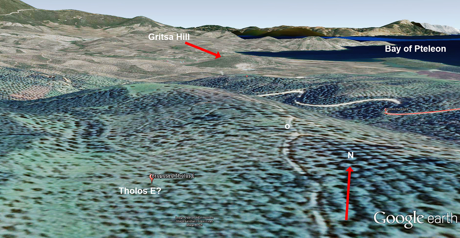
Illus. 9.  Proposed location of Tholos E with view to north.
In Illustration 9 I show what this would look like from above the ridges.  The position of Tholos E is marked and I've placed the letter 'o' in the closest position which would allow a view of Pteleon Bay and Gritsa Hill (which are also labelled).  From the position I've given to Tholos E to the letter 'o' is a little over 100 m. in a straight line.

As I said, this location satisfies most of the criteria along with the map.  I give the tentative information for tholos E as:

Name           Key no.        Latitude           Longitude          Error Term in m.     Date (from Pelon, 251)
Tholos E      C1689        39.006459° N   22.932909° E               50                         LHIIIA2

Objections could be raised for this proposed placement of mine.  For example the road as shown in the sketch map in Illustration 7 is oriented NE-SW (It is shown oriented, perhaps, 60°).  In reality the segment of road I've chosen is oriented slightly NW-SE (about 101.8°).   These little sketch maps may not always be the most accurate guides.  In my previous post on the little stone circle at Manesi there was another, more serious, example of such a rotational inaccuracy.


That's my best shot.  I could easily be wrong about this so if you know better where this little tholos is then please write to me.  I'm bobconsoli 'at' gmail.com

You can also just leave a comment at the bottom of this post and I hope you will.

And, by the way, thank-you to all of my faithful readers in 2016.  I wish all of you a Happy and Prosperous New Year!

If you like this post please follow me on Twitter.  I'm squinchpix.
Also I'm on Google Plus and I welcome followers.
And, regrettably, also on Facebook.  There I'm Robert Consoli.


Notes

[1] Simpson [1981], 'H 11 Pteleon: Gritsa', 164.

[2] My translation.  Pelon [1976] '41. Pteleon', p. 248.

[3] Pelon [1976] '41. Pteleon', p. 248.

[4] Idem.

[5] Simpson [1981], 'H 12 Pteleon: Ayios Theodoros', 164.  See also Ålin [1962] 146, 'Ajioi Theodoroi'.  "A town in the neighborhood of Pteleon.  On a little hill just north of the road, two km. before the town, Verdelis excavated a tholos tomb which had no relieving triangle.  It contained six burials and ceramics from the LHIIIA."  My translation.

[6] Pelon [1976], llus. CXXIII.   Reproduced by him from Verdelis [1952].  PAE, 1952, pl. 2, facing p. 192.  PAE is the Praktika tis en Athenais Archaiologikis Etaireias (Πρακτικα της εν Αθηναις Αρχαιολογικη Εταιρειας) which is now online.   Verdelis is the original excavator.  I have since found this diagram in Verdelis' article which is online here.  The diagram in the original article is rather more readable.


Bibliography

Ålin [1962]:  Ålin, Per.  Das Ende der Mykenischen Fundstätten auf dem Griechischen Festland.
Carl Bloms Boktryckeri A.-B., Lund, 1962.

Pelon [1976]: Pelon, Olivier.  Tholoi, tumuli et cercles funéraires; Recherches sur les monuments funéraires de plan circulaire dan l'Égée de l'Âge du Bronze (IIIe at IIe millénaires av. J.-C).  Bibliothèques de l'École française d'Athènes et de Rome - Série Athènes, 229. 1976.  Online here.

Simpson [1981]:  Simpson, Richard Hope. Mycenaean Greece. Park Ridge, New Jersey:Noyes Press, 1981.

Verdelis [1951]:  Verdelis, N. M.,  "3. Mycenaean tholos tomb by Agios Theodoros", Praktika tis en Athenais Archaiologikis Etaireias, pp. 150-154. 1951.  Online here.

Verdelis [1952]:  Verdelis, N. M., "7. Excavations in Thessaly", 1952. Praktika tis en Athenais Archaiologikis Etaireias, pp. 164 ff.,  Online here.

Segment Ro of the Cyclopean Wall is located again

    The segment of the Cyclopean wall which was named 'Ro' by Broneer (Mycenaean Atlas Project: C7760) has been relocated by my coll...