I mentioned in a previous post that my associate, Mr. Peter Barkevics, has confirmed the location of segment Pe of the 'Cyclopean' wall near Isthmia in Greece. The position of this segment is 37.913457° N, 22.997472° E.
 |
| Fig. 1. Area of the Isthmus. Blue way-mark indicates section Pe of the 'Cyclopean' wall. |
Zooming in:
 |
| Fig. 2. Area of the 'Cyclopean' wall. Section Pe is in the center at the blue way-mark. |
Section Pe was reported by Oscar Broneer in 1966 [1] and he provided a drawing of it:[2]
 |
| Fig. 3. Broneer's drawing of section Pe of the 'Cyclopean' wall. |
Overlaying the site re-established by Barkevics with Broneer's drawing gives this:
 |
| Fig. 3a. Google Earth image overlaid with Broneer's sketch of Pe. Broneer [1966] 350, fig. 2, no. 3. Elevation of the wall at the way-mark is 60 m. a.s.l. |
This wall segment is about 6 m from the edge of the modern road.
Broneer described Pe like this:
"One continuous stretch, Pe (Fig. 2,3; Pl. 81), in the property of Sotiris Peras, measures 45.50 m. in length. Only the outer, northern face is well preserved, in places to a height of two courses, but a few stones from the inner face show that the wall here had a thickness of 3.60-4.00 m. The stones are large, some measuring 1.50-1.75 m. in length and 0.75 m. in height. There are four towers, varying in width between 2.10 and 2.60 and projecting ca. 0.70 m. from the face of the wall. The distance from one tower to the next varies between 7.90 and 9.50 m. There was very little earth close to the wall, and the sherds found on the surface are mostly small pieces of undatable coarse fabrics. Two undecorated pieces might be Mycenaean."[3]
Two previous photographs of Pe are known to me - one appeared in Broneer [1966] [4]. The other appeared in Morgan [1999]. [5] To these old and now outdated photographs Mr. Barkevics has added some fifty color photos which detail the segment stone by stone. At the bottom of this next figure we see Mr. Barkevics diagram notes of the positions where his pictures were taken and, above that, my own diagram that tries to match his photos to Broneer's drawing.
 |
| Fig. 4. Upper drawing is Broneer [1966] 350, Fig. 2, no. 3. Lower drawing is Google Earth overlaid with Barkevics' way markers. |
Is this segment photographed by Barkevics the same as that shown in Broneer's photo? Yes. This next photo shows my labels for several of the stones in the Broneer photo:
 |
| Fig. 5. Broneer [1966] Pl. 81. |
This next photo by Barkevics shows the same stones with corresponding labels:
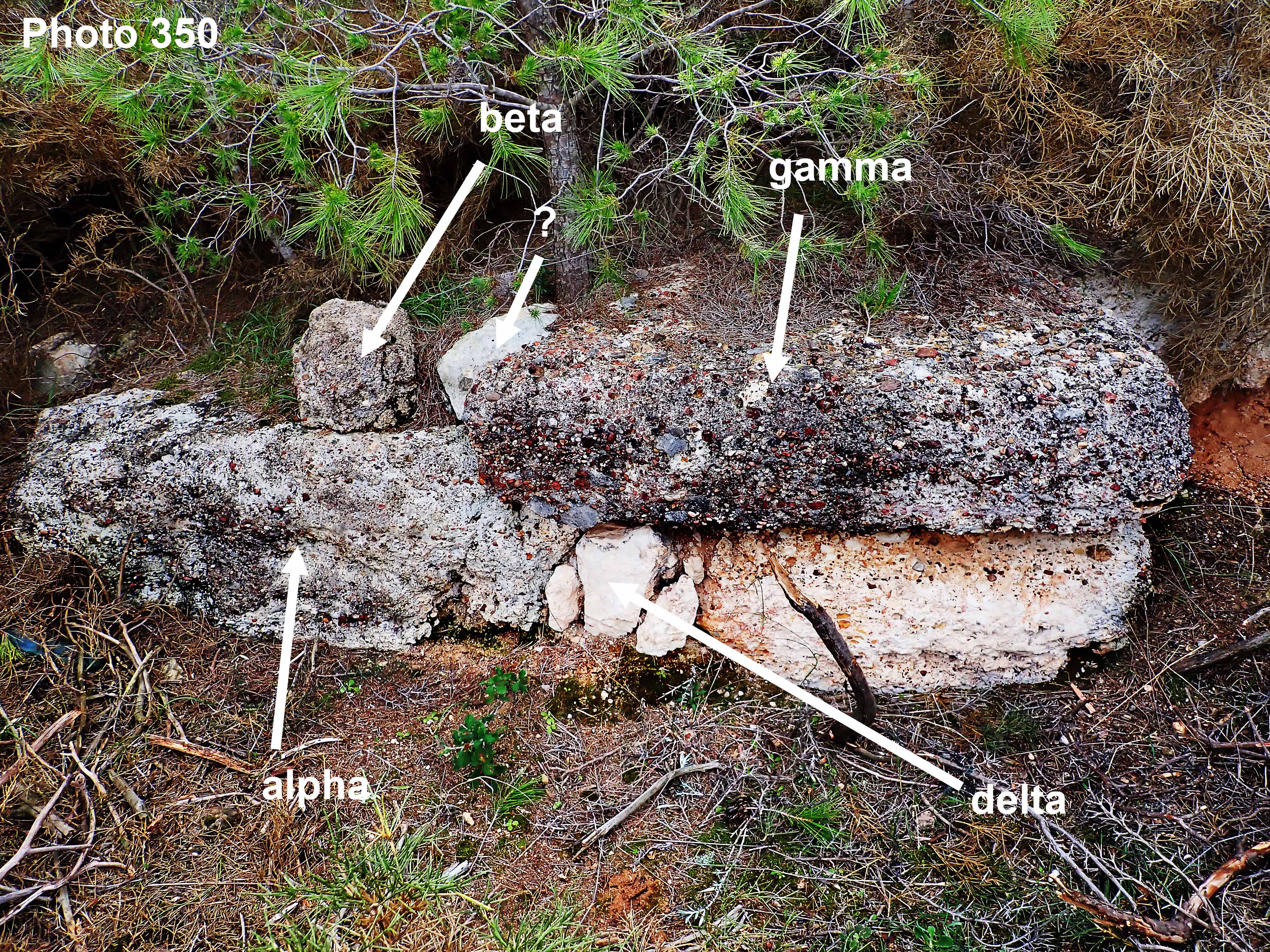 |
| Fig. 6. Tower 3 (from W). View is to S. |
I believe that stone beta has been moved and I may not have identified it correctly. Stone beta may actually be the next small stone (with the question mark) to the viewer's right. The other stones are clearly the same.
Following is a tour of the structure from the west to the east.
 |
| Fig. 7. Photo 325. The first two stones of the N face on the west. Viewer is looking S. |
This photo shows the first two stones in the sequence, starting from the west. This is photo 325 and you can see its position by looking at the left side of fig. 4 in this post. Here are the same two stones again (note the mossy patch).
 |
| Fig. 8. Photo 326. West end of N face. View facing S. The person is standing on the north edge of the modern road. |
 |
| Fig. 9. Photo 327. First tower from the W. |
This is the first (counting from the W) of the projections which Broneer identified as 'towers'. Their small size and the nature of the ground strongly suggest that they are buttresses.
 |
| Fig. 10. Photo 328. Same tower from the N and looking S. |
The second 'tower' from the left is shown in the next photo:
%20small.jpg) |
| Fig. 11. Photo 332. Tower 2 (counting from the W). |
... and another view of Tower 2:
.jpg) |
| Fig. 12. Photo 333. Tower 2 from a bit further back. |
The next photo gives another view of Tower 3 (already shown in Fig. 6):
 |
| Fig. 13. Photo 346. Tower 3. The view is to SE. Ten-euro note (127 x 67 mm) for scale. |
Another view of Tower 3:
 |
| Fig. 14. Photo 348. Tower 3 from N. View is directly S. Compare to Fig. 5. |
 |
| Fig. 15. Photo 351. East end of Tower 3 (from W). |
 |
| Fig. 16. Photo 357. Tower 4 (counting from the W). View from the E. Underbrush suppressed for clarity. |
It is difficult to escape the impression that section Pe is slowly being degraded by natural forces. Both erosion and the undergrowth (particularly pine trees) are going to dislodge more stones. The Archaeological Service might do a great deal of good by spending a day clearing brush around this very important monument.
In future blog posts I will publish more of Barkevics photos and then try to say what we have learned about the Cyclopean wall.
Footnotes
[1] Broneer [1966] 351.
[2] Broneer [1966] 350, fig. 2, no. 3.
[3] Broneer [1966] 351
[4] Broneer [1966] Plate 81.
[5] Morgan [1999] 443, fig. 8. Mislabelled 'Section Sp'. The correction is due to Simpson and Hagel [2006] 130, fn. 103.
Bibliography
Broneer [1966] : Broneer, Oscar. ‘The Cyclopean Wall on the Isthmus of Corinth and Its Bearing on Late Bronze Age Chronology’, Hesperia: The Journal of the American School of Classical Studies at Athens (35:4). 1966. Online here.
Broneer [1968] : Broneer, Oscar. 'The Cyclopean Wall on the Isthmus of Corinth, Addendum', Hesperia: The Journal of the American School of Classical Studies at Athens (37:1), 25-35. The American School of Classical Studies at Athens. 1968.
Kardara [1971] : Kardara, Chrisoula. 'The Isthmian Wall; (A Retaining Wall for a Road)', Athens Annals of Archaeology (4:1), 85-89. 1971. Online here.
Morgan [1999] : Morgan, Catherine. Isthmia VIII; The Late Bronze Age Settlement and Early Iron Age Sanctuary. The American School of Classical Studies at Athens, Princeton, New Jersey. 1999.
Simpson and Hagel [2006]: Simpson, R. Hope and D.K. Hagel. Mycenaean Fortifications, Highways, Dams and Canals. SIMA vol. 133. Paul Åströms Förlag. Sävedalen, Sweden. 2006.


No comments:
Post a Comment