I am happy to announce that the users of the Mycenaean Atlas now have the ability to examine distances from Bronze Age sites to the closest shoreline.
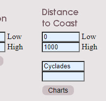
The main control page now features a new way for the user to specify a low and high distance.
 |
| The new control is in the lower center. |
 |
| Here is the new control in close-up: |
Having specified the range the user will see a new page that displays distances in four ways: a map of the returned sites, a list of the sites with distances to the shore, a histogram in which the sites are distributed into 'same distance' buckets, and a line chart in which the sites are lined up in distance order.
 |
| Analysis of sites within 1000 m of the shore. |
For example you may be interested in all sites within 1000 m of the shore. You specify 0 as the minimum distance, 1000 as the maximum distance and then you click on submit. The resulting four-part display will show you all sites within 1000 m of the closest shoreline: on a map, in a list, in a histogram, and on a line chart.
It may not be optimal to display the entire DB in this way; more researchers are interested in examining one island or region at a time. The control allows for that. If you want only to examine the Cyclades then you will type 'Cyclades' into the text input labelled 'Region' (and specify a range).
When you click submit you will see that the display is limited just to the Cyclades.
 |
| Result of selecting just the 'Cyclades'. |
This atlas considers individual islands as 'subregions'. If you wished to look just at Naxos in the Cyclades then type 'Cyclades' for the region and 'Naxos' for the subregion.
 |
| Selecting 'Cyclades' and 'Naxos' from the control |
 |
| The analysis page for Naxos. |
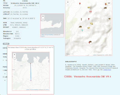
The individual place key site detail page has also been modified. Now if a distance to the ahore is defined for the site then there will be a label on that page that says 'Distance to Shore (click)'. When you click on that label a map will pop up that shows the site with a line drawn to the nearest shoreline. Click on the map to pop it back down.
 |
| Click on this to see site to shore map. |
 |
| The site to shore map with connecting line. Zoomable. Click on map to pop it down. |
The concept of shoreline poses some problems. 'Shoreline' is a dynamic concept and no precision is ever possible. There are the tides, of course. Distance to nearest shoreline depends on the time of day. And while I give figures precise to the decimeter the real distance may fluctuate tens of meters depending on the time of day. Here in the United States we have a joke about the State of Rhode Island which is said to be '5% larger at low tide.' There have also been dramatic changes in the shoreline since the Bronze Age. There is the case of Tiryns, of course. Formerly on the water's edge it is now more than a kilometer inland. Rivers have done their usual work in the last 3500 years. What were formerly islands are now landlocked by deltas as is the case for Aetolia-Acharnania. And there have been changes even more dramatic. The city of Helike in Achaea was drowned by earthquake and land subsidence in 373 BC. There have been changes in the ocean level which, combined with land subsidence, have led to differential variations in shorelines across the E. Aegean world. Nisakoula in Messenia is an illustrative case. Once a thriving settlement it is now submerged. Likewise Paulopetri in Laconia. The filling in of the Cothon harbor near Nestor's Palace in Messenia has placed that Palace further from the ocean than it would have been in the tthieteenth century BC. So the accuracy of my figures can certainly be questioned and in very few cases are they even accurate to within 10 m.
So if I cannot achieve absolute accuracy with my distances why, then, have I provided them? My readers should consider the 'distance to shoreline' as a classifying device. This new ability will quickly allow users to create lists of sites 'on the shore' (0 to 1000 m, say), 'a moderate distance from the shore' (2 to 5 km?), and 'inland sites' (perhaps sites further from the shore than 6 or 7 km). It would be very difficult to generate these classes in any other way. Why should my users care about these classes? Well, for one thing, distance from the coast might very well be reflected in diet and occupation. And there are obvious effects on the type of work that communities might perform.
How was this done and how were these figures arrived at? The first step in such work is to create a new DB table just to store site identifiers and distances. Populating such a table is the next step. This consisted of drawing in Google Earth an outline of all the areas involved. Such an outline consists of nodes and vertices. This is time-consuming and I experimented with different approaches. For Crete I traced the entire shoreline - some 4000+ nodes. For areas such as Attica I used a circle and node technique. In this method I drew circles centered on the various sites and only modeled those stretches of coast where the circles touched the shoreline. This resulted in significant savings in both time and labor
I then wrote a .php routine that would calculate the distances from each site to ALL the nodes and save the shortest distance along with the corresponding lat/lon pair for that point/node on the shoreline. In this system, as implemented, there is one and only one 'closest point' for each site even though many sites have access to the shoreline at two or more points at nearly identical distances. Some of these access points that are a little further away are objectively better for ocean access than the closest point. I save these difficulties for later discussion. In a potential refinement the current table could be combined with the data from Arthur de Graauw's harbor data.
This work of outline tracing is not yet completed. The areas that are done are
- Achaea
- Arcadia
- Argolid
- Attica
- Boeotia
- Corinthia
- Elis
- Laconia
- Macedonia
- Megaris
- Messenia
- Thessaly
Among the islands the work is completed for
- Antiparos
- Crete
- Euboea
- Kasos
- Kephalonia
- Kos
- Lesbos
- Melos
- Naxos
- Paros
- Rhodes
- Syros
- Thasos
- Thera


No comments:
Post a Comment