Thursday, February 8, 2018

Lost In Venice


‘In the Id the principle of non-contradiction does not apply.’
Freud

~~~

Night.   Bed.   

A susurrus of distant whispers; the surf on the Lido.  But it’s only S. breathing quietly on her pillow.

We travel in order to be lost.  If we want to be found we can stay at home.  It’s cheaper.

A feeling of alienation comes suddenly upon the traveler after having been in Venice for a few days.  Being lost there is not as it is in other places.  Being lost in the medieval warren that is Toledo in Spain is being lost in only two dimensions.  You’re merely displaced in linear space from where you wish to be.  But when you’re lost in Venice you’re lost in three dimensions; you’re not only displaced in a linear fashion from your desired destination, you feel as though you’re lost in some third, unspecified, dimension.  That’s confounding because Toledo is on a hill and Venice is as flat as a board.  There’s no way you can be lost in vertical space there but the creepy feeling is that you are.  Or perhaps it’s time that’s the missing dimension.  You have the feeling that not only are you not at your destination – that quotidian hotel, albergo, restaurant, cafe, or campo where you have arranged your rendezvous – it may not even currently exist. 

It doesn’t help that the map of Venice, when turned upside down, still looks right-side up.  Nor does it help that Venice, even at noon, is in a perpetual twilight and that every shop looks like one that you’ve seen just moments ago.  That paper shop; how familiar it seems.  Those are the identical leather bindings that we saw but half an hour since.  That shop of mascherie looks very much like the one we passed in the Ghetto.  Same owner?  Same shop?  Or is it coincidence?  Perhaps we’re not lost at all; we simply haven’t the wit to recognize that we’ve reached our goal.


 Average Venetians

Your senses are already overloaded by the exotica for sale: Paper goods, glass vases, parti-colored fish forever fixed in the glassy interior of a paper weight (85 inches around), masks, costumes, leather-bound books, capes, cloaks, tricornes, Punchinellos, antiques and faux antiques – Canalettos, Titians, Veroneses – all gently pulsing in the golden Venetian twilight.  Objects endlessly recurring in a riot of feathers, papier mache, leather, and silk.  A welter of swords, canes, and objets en verre.

A friend of mine explains in a restaurant – “A few years ago there was a butcher shop on this street and a drug store, – you could live here – Now it’s all masks, costumes, leather, and glass.”  He’s right.

Signs point in opposite directions – both say ‘Rialto’.

Another acquaintance confirms: “Street names mean nothing here, signore.”
Others solemnly warn you against Venice; ‘It’s not healthy.  The cold, the damp, molto artritico.’

To live here would be an agony; it’s cold, misty, foggy, and damp in the winter.  Spring brings warm rain and the mosquitoes (in 2002 I killed a dozen in my hotel room).  In summer the canals smell like drains .. and not good drains either.  The acqu’alta is likely to strike at any time.  Always there is the plague of tourists.  (And it is a plague; only Waikiki could possibly be worse.)  Only autumn (late September or October) is really bearable.

Venice is an enigma; it is the home of esoteric knowledge, of Hermeticism, of Kabbala, of the Tarot.  Why has it never found its Robert Byron or its Lawrence Durrell? [1]  It’s a scheme; Casanova planning his next conquest or your restaurant man passing off the shark as scallops.  

Florence is rational, a dream of the Renaissance emerging from the Medieval in a shower of rose-colored glories.  Venice is a grey contemplation of the Hidden and Revealed, of Hermes Trismegistus.  Venice’s patron saint should be Giambattista Vico for Descartes has no place here.    Ambiguity and obscurantism are the great themes of Venice.  Whenever I dream in Venice I’m always in a library.  I’m hauling down some musty volume of Casanova’s Vita or of Piccolomini.  I’m surrounded by volumes by A.D. Nock, by Festugiere, ..  , even Marx.  There’s a sense in my dream of real urgency; I’m always about to learn … it.    But I never do.   

Muddled identities, ambiguous sex.  Misrule; upset; reversal.  Love affairs by small bridges, of fights, strange cries and obscure alarms in the dark.  And how much is just oneself? The other day at sunset on the balustrade in front of San Marco, standing beneath the bronze horses, we heard a muffled thud; it sounded as though half of Venice had blown up.  It was only New Year’s fireworks; … perhaps I’m the only one who heard it.

Everywhere is the smell of fresh pastry.  It’s the cries of the watermen like birds of prey swooping by in their barchieti.   And around every corner the bright shop windows.  Last night a pretty shop woman said, ‘You speak Italian well!’ At the time I was paying her 800 euro for a turquoise necklace. 

Damp and dirty, decaying, decrepit (in San Marco the marbles are in ruins and cold as death); even to me the city seems to have gone downhill since I first visited in ’93.  The garbage lies in street corners; filth and decay, but then you wake up to a blanket of virginal snow.

The other day, (was it today?), S.  and I crossed over the Ponte ‘Storto or ‘twisted bridge’.  Who are they kidding? They’re all distorted.  And don’t get me started on the campanili.  They all lean at different angles (Santo Stefano looks on the verge of collapse); Pisa has little to boast of with just the single leaning campanile.
 
SS. Giovanni e Paolo, Santa Maria Formosa

But I was speaking of being lost.  Here’s an example of what happens:
Some time ago I determined to visit the Church of the Zanipolo (Venetian dialect for ‘SS.  Giovanni e Paolo’) and off I ventured.  I followed the map very carefully and – for my pains – was led to the Church of Santa Maria di Formosa.  A charming and important church, certainly, but not my destination.  I sat down, consulted the map and set off again.  By following the map to the letter it was only a short time before I was led, ineluctably, back to Santa Maria di Formosa.  In despair, and like the prophets of old, I lifted my face unto the sky and, to be sure, I could see the top of the Zanipolo’s dome.  Keeping it before my eyes – like the proverbial column of smoke – I was able to guide my faltering steps there.

After my visit I turned my back on it and crossed a little bridge away from the Campo di Zanipolo.  On the other side I turned – like Lot’s wife – and gazed back.  This giant Gothic church (the largest in Venice save for San Marco itself) had disappeared as utterly as though it had never existed.  It had gone back into the same imaginative space where we keep Aladdin’s cave – or Samarkand.   

For those who call the Zanipolo their own parish church the exterior world with its linear streets and strictly numbered houses must be as alien and disconcerting as the warrens of Venice are to the outsider.


Notes

[1] Although in the Alexandria Quartet, in Balthazar I think, there’s a brilliant bagatelle which has Venice as the setting.   Subject?  Vampires.   

Yes, I find it in Durrell [1958] 196:

“When I was twenty, I went to Venice for the first time at the invitation of an Italian poet with whom I had been corresponding, …”

Bibliography

Durrell [1958]:  Durrell, Lawrence.  Balthazar.  Penguin. 1958.   

Wednesday, January 24, 2018

The Magoula of Aghia Paraskevi

Finding a magoula can be tricky.  There is a good site for the magoulas of Thessaly and I strongly recommend it.[1]

Outside Thessaly, however, and unless the magoula has set of nice clear archaeological trenches on top of it, you have a difficult task.  No matter how imposing it may be in person, so to speak,  on Google Earth it fades into the surroundings.  Its two or three metre rise renders it nearly invisible.

Case in  point, Simpson's "C 58 Ayia Paraskevi: Ayia Marina" which I call C1600.

Here's what Simpson says:

"The "low mound" site of Ayia Marina lies on the north side of the Kephissos river, about 1.5 km. northeast of Ayia Paraskevi (formerly the Kalyvia of Agia Marina).  The site is not large (about 120 m. east to west by 100 m.), but trial excavations here established a long history of occupation, perhaps continuous from the Neolithic.  ... Some Mycenaean pottery was found.  It remains unpublished ... (etc.)"[2]

So.  Not really very important but let's find it anyway.  I include here a series of maps that allow us to zoom in on that area.  From furthest out they are:


In this map we're looking at a large section of eastern Boeotia.  I've circled the nearest biggish town to our magoula.  You can just about see that it reads 'Kato Tithoreia'.


In this second map we've zoomed in on Kato Tithoreia.  The mountain mass to the lower left is the north edge of the Parnassos massif.  I circled the town of Aghia Paraskevi as the closest small town to the magoula.


In this third map we've zoomed in even more.  The town of Aghia Paraskevi is at the lower center and the red circle surrounds the general area of the magoula.  Togoguide (from which these maps come) has even helpfully labelled this area 'Prehistoric Ceramic'.  So we've got to be close.  In every other way it agrees with Simpson's directions.

But can we find the magoula exactly?  It can't be seen in Google Earth.  What to do?

I was wondering about all this when there came to hand a copy of Livieratou [2006] in which the sites in Phokis and Lokris are discussed.  And there, on p. 111 was a full-color photograph of that very magoula taken from the south.[3]  Here it is:


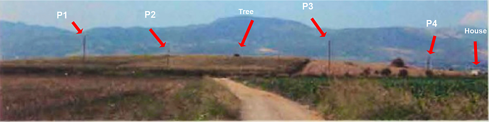
Ooof!  Not very good although I can tell you that it is much repaired over what it was.  Actually the photograph doesn't provide very much in the way of identifying information at all.  A mountain outline, a road, a rise, some telephone poles.  It's a kind of photographic haiku.

I went through, numbering the telephone poles and whatever other features I could pick out.  I took a good look at the outline of the mountain range to the N.  And I also took a very good look at that road in the foreground.  It might just be possible to find that road since we know what to look for.  Anyway, the result of my analysis produced this:


This shows the result of analysis.  I numbered the telephone poles from P1 to P4 and I was also able to identify a house at the extreme right edge and a tree growing on top of the magoula. 

Can we find those things in Google Earth?

I think so.  This is what I was able to do.


At the bottom center of this Google screen shot I put a push pin at the point from which I think the photograph was taken.  It's labelled 'Observer' and its coordinates are 38.594343  N, 22.750459 E.

If you want to follow this example you should get into Google Earth and try to find those telephone poles.  They're very hard to make out.  I may not have matched them up correctly but I think that they're correct.  The center of the magoula is at the blue marker.  I make it to be  38.595921° N, 22.750690° E.

O.k., you say.  'It looks like a rise in the ground but how do you know that there's really a rise there?  Maybe this is just normal fluctuation in Google Earth's representation?'

There's one last thing that we can do.  Google Earth provides a view shed feature.  From any point GE will indicate all the areas that can be seen from that point.  What happens when I invoke the view shed feature from the hypothetical observer's point of view?

I went ahead and did that and the results are as follows:


This is like the previous photo but with the view shed indicated in green.  Everything in green can be seen from the observer's view point which is at the bottom center of the screen.  Sure enough the rise in the foreground blocks out everything beyond until we reach the mountains.  Just as in Livieratou's photo with which you should compare this.

QED.

Updated 1/24/2018, evening.

If you look in the letters section you'll see that Anonymous encourages me to set the vertical exaggeration factor to 3 in order to magnify the vertical differences and make the smaller rises easier to spot.     Anonymous is right.  Manipulating the VE can often be incredibly helpful.   In fact I’m constantly going back and forth between 1 and 3 on the vertical exaggeration control.  But despite that I’m not convinced that setting the VE to 3 in this case gives us any unambiguous evidence.

Here’s a trick that I also like to use.

Click on the path control and then draw several path lines directly over the feature you’re trying to learn more about.  I show a path here that is an example of what I mean.  The location is the same as in the post, C1600.


The blue paddle here marks what I think is the center of the magoula.  Once you’ve drawn this multi-segment path put your mouse pointer on one of the segments and click on the right mouse button.  This will pop down a menu.  Click on the second choice from the end: ‘Show Elevation Profile’.


When you do that GE puts up a display that shows the heights for every point on the line.  


If the line you drew doubles back on itself the appearance of the elevation profile is vaguely periodic.  That just means that heights and depths are more strongly pronounced and seem to reflect each other.  It’s like taking slices out of the magoula.  You can quickly see where the high and low points are and how different they are from each other.  GE also shows you the maximum height; here 142 m. – and the low which is about 135 m.  This is a difference of seven m. or about 22 feet.   Sounds about right for our magoula.   It turns out that the high point is about where I thought it was.  Remember that the heights shown are only along the figure you drew.  It amounts to an elevation sampling.  

You might do this several different times with different paths before you decide what’s what.

You can also do this in GE with circles or just simple straight lines.  But I find that the multi-segment path is very useful.  This is a powerful technique and I urge all of you to experiment with it.

Mycenaean Atlas Project.

For the Mycenaean Atlas Project DB release 50 has been delivered.  It substantially completes the integration of some 400 sites whose locational information was furnished through the generosity of Dr. Alex Knodell of Carleton College.

If anyone has corrections, additions, doubts, etc. about anything on the website then please send them to bobconsoli 'at' gmail.com

Here at MAP we always want to hear from people.  Follow me on Twitter (@squinchpix) and on Google Plus (Robert Consoli).  Please do it.  I need your support!

Friends don't let friends use Facebook.


Notes

[1] The Innovative Geophysical Approaches for the Study of Early Agricultural Villages of Neolithic Thessaly whose website is here.

[2] Simpson [1981], 79.

[3] Livieratou [2006] 111.


Bibliography

Livieratou [2006]: Livieratou, Antonia   After the palace and before the polis: study cases from the centre and the periphery; The transition from the Late Bronze to the Early Iron Age in the Argolid and Central Greece (Phokis - East Lokris), Vol. 1, Dissertation for the Degree of Doctor of Philosophy, The University of Edinburgh, 2006.  It is online here.

Simpson[1981]: Simpson, Richard Hope. Mycenaean Greece. Park Ridge, New Jersey: Noyes Press, 1981.


Wednesday, January 3, 2018

Database 48 delivered


For the Mycenaean Atlas Project site: Helladic.info -

Database MAP_Rev_0.048__01_03_17 (DB 48) has been delivered.  It contributes some thirty new sites and approximately 100 new place features.  It continues the integration of contributions from Professor Alex Knodell of Carleton College.

Search table files are also updated.

Tuesday, January 2, 2018

The location of Amarynthos: Palaiochoria (C1223)

I’ve been looking just now for the site of Amarynthos: Palaiochoria on Euboea.  This was a small Mycenaean habitation site in the LHIIIB and LHIIIC.  I have called this ‘C1223’ and I originally placed it at 38.386937°, 23.924491°.  I am now convinced that this is not correct and I found out about this in an interesting way.  Let’s start with the sources.

       a)      Sackett et al. [1966] say “This is a prominent hill, whose cliffs project slightly into the sea, about 2 km. to the east of Amarynthos and at the extreme east end of the Eretrian plain where Mt. Kotylaion reaches the sea.  Beyond it the road winds sharply over ridges to the long stretch of inhospitable rocky coast leading to Aliveri.  The hill is surmounted by two Byzantine churches (one set very prominently on the cliff’s edge) and the remains of a third, which was constructed partly on earlier foundations of ancient blocks. The surface of the hill (c. 250 x 150 m. in area) is flat and cultivated, as are the steep sides to east, north, and west.  The small sheltered beach immediately below the site to the east is the first possible landfall for a ship travelling westwards from Aliveri, and to the west flat land and a shelving beach stretch all the way to the harbour of modern Amarynthos.”[1]
      
      b)      Simpson [1981] says: “Palaiochoria (or Palaioekklisies) is a prominent low hill, about 2.5 km. east of Amarynthos, and at the eastern end of the plain of Eretria.  The cliffs on the south side of the site project slightly into the sea, and provide some shelter for the small beach immediately below the site on the east.  To the west of the site, flat land and a shelving beach stretch up to the harbour of modern Amarynthos.  The hill is crowned by two Byzantine churches and remains of a third, which was constructed partly on ancient foundations.  The upper surface of the hill, about 160 m. northeast to southwest by 85 m., is flat and cultivated.”[2]

What are we looking for:

1)      It is a hill.
2)      It is on the coast and projects slightly into the water.
3)      It is on the extreme E of the Eretrian plain
4)      It’s between 2 and 2.5 km. from modern Amarynthos.
5)      There are two churches on the hill; one next to a cliff or drop
6)      The surface of the hill is 250 x 150 m. in area.  Perhaps it is 160 m x 85 m.
7)      There is a beach below the site to the E.
8)      The hill is cultivated.

Now these are mostly weak and undiagnostic criteria.  Nos. 1, 2, 7 are useless because these three things are characteristic of much of this Euboean shore.  No. 3 is a little more interesting but too vague to be of much help.  No. 4 deserves special condemnation.  Not only can our authors not agree but they do not say when this distance was estimated, whether the distance is from the center or the edge of town, and whether it is straight line or by road.  No. 5 is not very useful because there is at least one other location on this shore where this is true.  No. 6 only tells us that the hill is of modest dimensions; like most of them in this area.  No. 8 raises another problem.  When was it cultivated?  Is it still cultivated more than half a century later?

What to do?

I tried looking for churches but the only one I could find was Aghios Konstantinos at 38.385011° N, 23.924209° E.   ‘Eureka!’, I thought.  Here’s a modest hill, right on the water, with a church and a sheltered beach on the east and it fits all the other vague criteria.  


That became my C1223 and I went on to the next site.

Dr. Alex Knodell of Carleton College has recently been kind enough to supply me with some geo-locational data for this area and he has placed my C1223, Amarynthos: Palaiochoria, at a very different  place:  38.3863153 N, 23.91034726 E, which is about 1220 m. to the W of my site.

I wasn't convinced.   ‘How can this possibly be?’, I thought.

Here's a photo of Dr. Knodell's site:


I took another look at his site and certainly there appeared to be a church on the edge of a cliff.  ‘Could this be?’, I wondered.

I went back to Sackett and took a look at his photograph of the site (I don't think that I'd done this originally).[3]  Here it is:


I improved the contrast of the original picture and added the arrows and labels.   'O.k., there's the church and what looks like the same tree in the right spot.'  But I wasn't truly convinced until I found this user supplied photo on Google Earth.   A vacationer had almost perfectly reproduced Sackett's photo.

The photo is pinned to  38.385969° N, 23.907693° E and here it is:

Photo by Nikos Nikos whose photo galllery on Panoramio is here.


(God, what is that?  A Coke slushee?)   Behind the miraculous floating drink is a nearly perfect recreation of the cliff, the church, the tree, and the hill.  Compare it to the photo just above.


So, there you have it.  We mustn't despise knowledge sources no matter how humble.  

In fact, I think everyone has known where this site is except me.  There's an extensive bibliography in Sackett and even Simpson gives a sketch map which, once you know the real location, makes perfect sense.  But if you look at it without knowing the real location it seems to fit my original location better.

Update on January 7, 2018

There was quite a bit of interest in this post.  Alex Knodell wrote in to clarify some of the terminology.  The two churches on top of this bluff are called 'Palaioekklisies' or just, 'those old churches'.  The one I referred to in the post is called the church of the Kimisis Theotokou (Panaghitsa).  The other, older, church is the church of the Metamorphosis.  If you look for them in Google Earth you'll notice a nice user-contributed photo of the older church, the Metamorphosis; the picture is labelled in Russian:  Древняя Часовня or 'Ancient Church'.  This photo is posted at 38.386612 N, 23.910107 E.  

Alex Knodell was kind enough to send me one of his own pictures of this area.  This photo was taken from behind the smaller and older church, the Metamorphosis, and facing W.  The larger church on the bluff is on the left of this photo along with a piece of the giant tree on the face of the bluff which I mentioned earlier.  It appears to be some kind of Eucalyptus.  On a side note there are too many of these hydrocarbon-bomb Australian natives in Europe.  Portugal is covered with them and they are the major culprit in the forest fires that P. experienced recently.   Anyway, here is Alex' picture:


I lightened the shadows in this picture, removed some of the blue from the shadows, and punched up the color somewhat.  You can see more of those Eucalypti.

There was some discussion about the nature of the drink in the user-supplied photo which I reproduced in the original post.  I thought it was some sort of slushee but the consensus is that the drink is a frappe and, in the interest of ethnographic documentation, I reproduce Alex Knodell's description of how these are made:

"..., the frappe is the quintessential Greek cold coffee drink, made of nescafe, sugar, and water,  whipped up with a little gizmo that looks like a milkshake machine. It will give your system a caffeine catapult into instant alertness while at the same time roiling your insides in an equally unique way."

Another correspondent, Jacquelyn, also identified this drink as a frappe.

Wikipedia is all over this; see the article: 'Frappé coffee' and especially the section entitled 'Greek frappé variations'.  I was curious about Alex' frappe maker and found one for sale on EBay.

Both Alex and Brady Kiesling brought to my attention the fact that Amarynthos is the site of the recent discovery of the sanctuary of Artemis Amarysia.  A recent account with photos is here.

You can see the excavation in Google Earth here:


Alex Knodell's latest book, Regional Approaches to Society and Complexity has now appeared.  You can learn more about it here.


Mycenaean Atlas Project.

New database (Rev 0.048) has been delivered to the MAP.   I am currently in the process of integrating geo-locational data for many places in central Greece and which was kindly supplied to me by Dr. Alex Knodell of Carleton College and Sarah Murray of the University of Toronto.

I always want to hear from people who have corrections or ideas about new sites that are not yet in the Atlas.

You can reach me at bobconsoli 'at' gmail.com

My google plus link.

You can follow me on Twitter.

Friends don't let friends use Facebook.


~~~~~~~~~~~~~~~~~~~


NOTES

[1] Sackett et al. [1966], 64, ’62. Amarynthos: Palaiokhora’.
[2] Simpson [1981], 55, ‘B 70 Amarynthos: Palaiochora’.
[3] Sackett et al. [1966], Plate XVI(a).

BIBLIO

Sackett et al. [1966]:    Sackett, L.H., V. Hankey, R.J. Howell, T.W. Jacobsen and M.R. Popham.  "Prehistoric Euboea: Contributions toward a Survey", The Annual of the British School at Athens, 61, pp. 33-112, 1966.


Simpson, Richard Hope. Mycenaean Greece. Park Ridge, New Jersey: Noyes Press, 1981.

Saturday, December 16, 2017


Spring is coming


As a break from our regularly scheduled Bronze Age posts we bring you this:

Filoli Gardens

Thursday, December 14, 2017

Finding the site of Malesina - Hagios Georgios in Locris (C5169)

I'm currently integrating Bronze Age sites from Kramer-Hajos [2008] into the Mycenaean Atlas Project.. 

Kramer-Hajos' work deals with Bronze Age sites in Locris; it's probably the best overall source for Locris currently in print.  Some of her sites are quite obscure, not well-known and not published.  More than that I'm having trouble following her directions; particularly for the site of Malesina - Agios Georgios.


Here's a map of the general area.  The town of Malesina is at the lower left and I give its coordinates on the right.  Just to the NE of the town is the monastery of Saint George.

The actual site of Malesina - Agios Georgios consists of five excavated chamber tombs and in one of them a Mycenaean sherd was found.  The relative insignificance of the site is reflected in the obscurity of her directions.  See what you think:

"Directions: From Malesina, follow signs northward to the Agios Georgios monastery.  Pass by it and keep going north to the steep slope towards the sea.  Take the second road to your left, a sharp turn, and again the second road to your left.  Continue on the dirt road until it turns right.  In the hill on your left five excavated chamber tombs are visible."   (1)

Huh?  This is a good example of the kind of thing I'm always complaining about.  Is it too much trouble just to locate the thing with a lat/lon pair?  Apparently it is.  There are several ways to parse her directions but let's take it apart and look at it piece by piece.

a. follow  signs  northward to the Agios  Georgios  monastery.
b. Pass  by  it  and  keep  going
c. north to the  steep  slope towards the sea.
d. Take the second road  to your left ,
e. a sharp  turn,
f. and  again  the second road to your left .
g. Continue  on the dirt road  until  it  turns  right.
h. In the hill on your left five excavated chamber tombs are visible.
i. In one of them a Mycenaean sherd  was  found.

Let's take these one at a time and at the same time follow along on the map that I've made:


The first three steps are shown in the photo above.  Point A represents coming to the Monastery road from Malesina.  Point B corresponds to 'Pass by it and keep going ...'.  Point C represents the first problem.  Here you can go left or right but KH does not tell us which.  She simply says 'north to the  steep  slope towards the sea.'  I prefer going to the right (East) here.

In step D KH tells us to take the second left.   Here's what I think that looks like:


Continuing on from the turn at C we pass the driveway on the left (turn 1) and reach the fork at D (turn 2) and take the left fork.  That's what I believe she means by taking the second left.  That would make the sharp turn in step E correspond to the sharp turn at E in the photograph.


Now in this photograph we are following on from the curve at E in the lower right.  We pass the first left turn at '1' and then we come to the second left turn at '2'.  This corresponds to 'F' in our list of instructions.  We turn onto that road and go on until it turns 'right'.  I make that to be the point marked at 'G' on the photo.  The actual Chamber tombs are somewhere 'to the left'.  I've drawn arrows to show what I think that that means.  I've put the constructed location at 'H' but the tombs could easily be 50 m. or so to the east of this point.

Anyway, that's what I've been able to make out of her directions.  I'd put the odds of this reconstruction being correct at about 50%.  And when giving directions using the terms 'right' or 'left' please remember my cautions in the essay #Things_Mycenologists_Say which I linked to above.

Mycenaean Atlas Project.

I just delivered what I hope is a much-improved software version for this site.  It features a much better search facility but one which does not eliminate what was already there.  For the new features you can see the usage page which I rewrote.  Find it here.

Large changes like these can introduce lots of new problems and errors.  Please e-mail me with a complaint if you experience some bug or other.  I always want to hear from people who have corrections or ideas about new sites that are not yet in the Atlas.

You can reach me at bobconsoli 'at' gmail.com

My google plus link.

You can follow me on Twitter.

Friends don't let friends use Facebook.

~~~~~~~~~~~~~~~~~~~


Notes

1. Kramer-Hajos [2008] 51.


Bibliography

Kramer-Hajos [2008]:   Kramer-Hajos, Margaretha.  Beyond the Palace: Mycenaean East Lokris, BAR International Series.  2008.,  "Malesina - Agios Georgios", 51.

Thursday, December 7, 2017

Major Changes on Helladic.Info (12/06/17)


Previously this website supported a miscellany of search methods.  There were separate methods for place-name search, place key search, and regional site search.  In this new release these methods have been combined into a generalized search method which now appears on all pages.  You can search for all the things you could formerly search for.  In addition any text string can be searched on and every instance of that string in the database will be returned with a link to the site page or feature page on which that string appears.  For example, strings such as 'vasilios', 'Simpson', 'Banou', etc. can now be searched on.

There is a new Feature Key page which gives basic information about all features (which are non Bronze Age things such as bridges, towns, churches, etc.).  Features can be searched for by using their feature key (which always begins with an 'F'), e.g. ‘F346’.

Sites can now be searched on by using the place key identifier (which always begins with 'C'), e.gg. 'C100', 'C5140'.

Regional site search now functions differently.  When you input a regional name such as ‘Laconia’, for example, you will see a list of all the sites in Laconia along with every other use of the term ‘Laconia’ on the web site.


There is a new Search Results page.

A new Database (MAP_Rev_0.045__12_06_17) has been delivered.  This new DB supports the enhanced search facility.

A change of this magnitude usually turns up glitches.  Please report problems to 

bobconsoli "at" gmail.com

An enhanced site usage section for the new changes is currently being prepared.

Wednesday, November 22, 2017

Further reflections on a Methodological Problem: The argument that Cyclopean walls were built to display status or power


'He's large.'
Olive Oyl sings about her upcoming wedding to the villain, Bluto.
Lyrics by Harry Nilsson.
"Popeye", 1980


In a previous post I made much of the fact that many Mycenologists have claimed that a major motivation for the building of Cyclopean fortresses was ‘projection of status’ and ‘exhibition of power and/or wealth’. I presented citations from a number of scholars who, in my view, have committed this methodological error.


Mycenaean art installation or did it have utilitarian purpose?
East walls of the citadel of Tiryns. Observer facing SW. Perhaps mid-14C BC.


In addition to the citations in that post I have since discovered that Nancy Loader makes this idea the organizing principle in chapter two of her Ph.D. dissertation. She has this to say:

“Although the size and structural arrangement presupposes that Cyclopean masonry was used for its strength, its appearance also suggests that it provided a means by which to convey wealth and prosperity of the territory within which it was based. This does not imply that defence was not a consideration of the Mycenaeans, but that danger was by no means imminent." (emphasis mine)”[1]

In this post I want to take a closer look at the logical problems which this type of claim raises.

To start, the claim that the Cyclopean fortress walls were intended to display power, wealth, status, what-have-you, is an emotional projection into the past. That this is the case is admitted by Schofield who says that since she’s impressed then everybody must have been. [2]

This resort to psychologizing about the motives of the Mycenaean leaders[3] raises many problems, not the least of which is the problem of consistency. We see this from our own citations which I have put into tabular form:


Scholar[3a]
Motivation
Maran
hardness, inapproachability, power
Hitchcock
power
Schofield
impressiveness, status
Wright
power, status
Dickinson
enhance prestige, display wealth, display power
Loader
convey wealth, convey prosperity


Our scholars, as seen by this table, do not themselves agree on what message the Mycenaean leaders are trying to convey. For our modern savants the walls appear to be a Rorschach test. Do the walls convey ‘wealth’, ‘power’, ‘prosperity’, ‘hardness’, or ‘inapproachability’? The differences are not resolved. Nor can they be. Each observer brings his or her own unique life experiences to bear. Each of our scholars commits the fallacy of the Universal Man; which ‘assumes that people are intellectually and psychologically the same in all times, places, and circumstances.’[4]

I have to remark that such statements betray an impoverished ethnographic awareness on the part of our scholars. More experience with traditional and/or tribal cultures would have shown that there is a rich range of emotional states and attitudes that can be retrojected onto these walls. Why should our mental palette be limited to displays of power, prestige, or wealth? If we’re going to intuit mentalities why not go all the way?


1. It’s entirely possible that the creation of these walls was looked on as a great communal project in which all participated; an expression of ‘nationality’ (if I may be allowed such an anachronistic word here), ‘communitarianism’, or solidarity.

2. Perhaps the walls were intended as a display of up-to-date technical know-how.   On this showing the walls would be an example of the scientific prowess on the part of the Mycenaean leadership; a display of Mycenae’s modernity.

3. The Mycenaean lords may have performed violent and bloody deeds on their subjects and the walls were intended to conceal such practices. In such circumstances the walls would inspire, and were intended to inspire, fear and trembling.

4. Perhaps there was a myth, now lost, of the ideal dwelling place of the Gods - a kind of Mycenaean Valhalla which the walls were intended to replicate and invoke in the mind of the viewer.  Or, what the heck, maybe they were intended as a representation of the seat of the Gods on Olympus.  In other words the walls would be a display of religious content.[5]

5. The walls may have originated as a giant unemployment project; a kind of Mycenaean Keynesianism in times of stress. Onlookers of the time might have viewed the walls with gratitude and as a symbol of the beneficence of wise and generous rulers.[6]

6. In order to get the walls built (for whatever reason) the Mycenaean rulers may have had to quash the powers of various lords who refused to provide corvée labor and rations for the work at hand. As a result the walls may communicate feelings of joy (or the reverse) at the crushing of the nobility and represent the final emergence and consolidation of a Mycenaean paramountcy or kingship.[7]

There’s no end to the mental states that we can project onto these walls but, as the question is fundamentally undecidable, I forbear.


It's not difficult to see from where it is that our scholars derive their views. There is warrant for this type of reasoning in anthropology. In a well-known article from 1996 the anthropologist Elizabeth DeMarrais describes the concept of 'materialization'. This is defined[8] as the making visible of symbolic and ideological concepts in the form of material production. This includes, but is not limited to, such things as elaborate costumes and weapons, monuments, writing systems, and even ceremonies. In general, I believe, Dr. DeMarrais and her co-author Timothy Earle mean this word to cover all instances of ideological reification no matter what form they take or in what medium they are expressed. And these other scholars whose views I have just been describing are treating the Mycenaean walls (and, par extenso, other practical projects among the Mycenaeans) as objects of materialization in the sense intended by DeMarrais et al.

Is this legitimate and did DeMarrais and Earle understand walls to be includable in this category?
In their article DeMarrais and her co-authors have this to say:

"Public monuments and landscapes - mounds or pyramids, ceremonial facilities, large buildings and centers of political activity, or defensive structures - associate a group with a place and represent the power and authority of its leaders."[9]  Emphasis is mine.

So it appears that the usage of this term by DeMarrais et al. would include Cyclopean construction of walls (and every other Cyclopean construction) among those objects suitable to be described as materialization of the ideology (and pretensions) of the ruling class.

But this is a self-evident absurdity because the instant that DeMarrais utters the word 'defensive' she removes that object from the realm of ideology and transfers it to the realm of practical necessity. In order for us to believe that a vitally necessary structure is simply an instance of propaganda (DeMarrais presents no examples[10]) we would have to suppose that every possible activity of the ruling class must be subsumed under the activity of ideological broadcasting no matter the practical emergency to which it may be a response. Any activity of the ruling class that results in a physical manifestation of whatever kind must, by this definition, have only the purpose of announcing the importance of the ruling class and the cogency of the ideology that supports it. In the extreme case we should suppose that, faced with a real live enemy, the King who hands out swords to his army is spreading his ideology through the materialization of weapons.  This lends a weird air of abstracted unreality to the discussion. Sometimes a sword is just a sword and a wall is just a wall.

This type of reasoning subtly predisposes us to think that all Cyclopean wall building and, more broadly, all building projects on the part of the Mycenaeans were about the display of ideology, power, or wealth.

And that is flatly untrue.[11]

For example, it would be very difficult to accept that the 22+ km wall which the Orchomenians built around the northern edge of the Copais Basin for the purpose of draining the lake (the wall was 30 m wide in places [12]) was done as an expression of wealth and prestige. This project, the largest in the Mycenaean world, was (and we are as sure as we can be given the nature of the data) part of a massive land reclamation scheme; virtually certain to have been initiated by the rulers of Orchomenos and exploited for their benefit alone. If I may be allowed a tautology it was the wealth of the Orchomenians which was their projection of wealth.[13]

In the thirteenth century BC a large port was built near Pylos.[14] I think it would be silly to suggest that this port was built in order to project the wealth, power, or status of Pylos. It was made to harbor trading vessels, tout court. The same observation may be made about the diversionary dam outside of Tiryns or the land reclamation project near Nemea. These great projects were strictly utilitarian and, while I’m sure that a case could be made that Bronze Age builders worked with care and consistency, the idea that these constructions arose from motives of aesthetics, vanity or display is exceedingly unlikely and not demonstrated.

This methodological error is compounded - as I noticed last time - by a reliance on the false dichotomy of 'defense' vs. 'display' and prevents us from searching around for alternative explanations. As I suggested in my previous post, there are alternative utilitarian explanations for the cyclopean fortifications which do not rely on the backwards projection of emotional states.

Update on 11/25/17

Richard Hope Simpson refused to have anything to do with the idea that Mycenaean walls and towers were built for aesthetic purposes.  Above all he emphasizes the defensive role that they played and he also pushes back against Bintliff's idea that absence of warfare meant that the walls must have been built for display.  'Defensive measures, in the form of walls or other barriers, do not necessarily imply the absence of peace, nor do they presuppose any warlike disposition.  Indeed such static defences often signify the exact opposite (e.g. the French pre-World War II Maginot Line).' [15]

Simpson also points out that the power of these societies depended on agricultural produce and that walls were a way to secure both that and the population that produced it.[16]

Endnotes

[1] Loader (1995) 30. Dr. Loader traces this idea to Iakovidis (1983).

[2] Schofield (2007) 78-9. Referring to the walls she says “They certainly are, even today, awe-inspiring.”

[3] If fact this particular argument does not psychologize about the Mycenaean leaders themselves. It psychologizes about these leaders’ speculation about the desired psychological impact on their subjects and unnamed others – a double remove.

[3a] Maran [2006] 79; Hitchcock [2010] 206, 208; Schofield [2007] 78-9; Dickinson [2006] 36,42; Loader [1995] 30. Middleton [2008] 152 follows Dickinson into the same trap in his Ph.D. dissertation.  Wright [2006] 59.

[4] Fischer (1970) 203 ff. ‘People, in various places and times, have not merely thought different things. They have thought them differently. It is probable that their most fundamental cerebral processes have changed through time. Their deepest emotional drives and desires may themselves have been transformed. Significant elements of continuity cannot be understood without a sense of the discontinuities, too.’ We would be closer to my own thought if we added to Fischer’s description the words: ‘These differences must be presumed to exist because people were and are enculturated differently.’ And how differently is difficult for us to grasp without extensive exposure to ethnography. If my, admittedly non-specialist, reading in modern research on neural networks and their training is applicable at all to physical changes in the learning brain then Fischer's statement '.. their most fundamental cerebral processes have changed through time ..' will be the literal truth.

[5] It is appropriate here to quote Geertz on the nature of the Balinese state and the doctrine of 'the exemplary center':

'This is the theory that the court-and-capital is at once a microcosm of the supernatural order - "an image of ... the universe on a smaller scale" - and the material embodiment of political order.  It is not just the nucleus, the engine, or the pivot of the state, it is the state.  The equation of the seat of rule with the dominion of rule, which the negara concept expresses, is more than an accidental metaphor; it is a statement of a controlling political idea - namely, that by the mere act of providing a model, a paragon, a faultless image of civilized existence, the court shapes the world around it into at least a rough approximation of its own excellence.  The ritual life of the court, and in fact the life of the court generally, is thus paradigmatic, not merely reflective, of social order.  What it is reflective of, the priests declare, is supernatural order, 'the timeless Indian world of the gods" upon which men should, in strict proportion of their status, seek to pattern their lives.'  Geertz [1980] 13.

Thomas Palaima provides a discussion of what can be known about Mycenaean religion based on Linear B sources in Trzaskoma et al [2004], 'The Gods in Linear B Tablets', pp. 443-454.

[6] Potentially a major factor in traditional societies.  James C. Scott emphasizes the role that Keynesian economics can play in his examination of the peasant societies of south-east Asia. 'It is entirely possible that the Hindu and Buddhist doctrines of the responsibility of the king for the welfare of his subjects made for monarchs who went easy in times of dearth and devoted much public  revenue to irrigation works and public relief.' Scott [1976] 93, n. 6.  Scott sees all such schemes as part of the peasant's 'moral economy'.   The first and primary function of the moral economy is to keep the peasant and his family alive and it may be understood as a set of remissions and redistribution schemes that function to prevent disaster in times of want.

[7] This was the sequence of events in Hunza in the early 16th and 17th centuries. The Mirs had to destroy competing clans in order have access to the men and rations that would enable the creation of the great irrigation projects there. See Sidky (1996) 50-51.

[8] DeMarrais et al. [1996]. And for an additional discussion of 'materialization' in the Hawaiian context see Kirch [2012] 291-2, 298. Kirch names, as examples of materialization, the temple platforms, full-time priesthoods, awe-inspiring ceremonies and displays, as well as such things as elaborate feather-work as well as whale tooth pendants for the Hawaiian elite.

[9] Ibid. 18.

[10] DeMarrais mentions those constructions that could come under the label of 'materialization', namely, pyramids, great grave sites, etc. Nowhere can I find that she lists actual defensive structures or walls. Nor does Earle himself. In Earle [2002] 356 we read "Public monuments and landscapes are mounds or pyramids, ceremonial facilities, large buildings and centers of political activity, or defensive structures that associate a group with a place and represent the power and the authority of its leaders." Emphasis is mine. But when he comes to list such objects (356-7), once again, true defensive or offensive structures are omitted.

[11]  For a good example of this cross-contamination of ideas, Tartaron et al., in a valuable paper about the recently discovered LH habitation and port at Kalamianos in eastern Corinthia, when discussing the placement of large stones at the corners of walls (quoins) or in doors  (jambs), say this

"The stones used in wall construction at Kalamianos vary greatly in size, but even in relatively small structures many of the stones are remarkably large.  Blocks 1 m or more in length are not at all uncommon, and this gives many walls a “cyclopean” appearance (Fig. 18). While the ready availability of large stones at the site might account for their liberal use, care was apparently taken to set them in conspicuous positions, whether they are worked (at corners or near doorways) or unworked (especially on the eastern facades of buildings). This careful placement of large blocks, along with the use of the lighter-colored, banded limestone blocks in similar positions, recalls the use of conglomerate blocks in the palaces at Mycenae and Tiryns, where James Wright has argued for their deliberate employment as a display of palatial power."   Tartaron et al. [2011] 584.  Emphasis is mine.

The reference to James Wright is Wright [2006] 59.  I have discussed Dr. Wright's position here.

[12] Diagrams and measurements in Kalcyk and Heinrich (1989) fig. 4-2, p. 59; fig. 4-5, p. 67.

[13] Orchomenos’ wealth was proverbial. Iliad, IX.381 [LCL 170: 422-423] "… all the wealth that goes to Orchomenus"; Iliad, V, 706-9 [LCL 170: 258-259] "Oresbius with flashing apron, who dwelt in Hyle on the border of the Cephisian lake, greatly concerned for his wealth; and near him dwelt other Boeotians having a land exceeding rich."; Pausanias,Boeotia, XXXVI.4 [LCL 297: 335 ] "The revenues that Minyas received were so great that he surpassed his predecessors in wealth."; Boeotia, XXXVIII.7-8 [LCL 297:345] "It is not likely either that the Orchomenians would not have discovered the chasm, and, breaking down the work put up by Heracles, have given back to the Cephisus its ancient passage, since right down to the Trojan war they were a wealthy people. There is evidence in my favour in the passage of Homer (Iliad ix.381.) where Achilles replies to the envoys from Agamemnon:— 'Not even the wealth that comes to Orchomenus', a line that clearly shows that even then the revenues coming to Orchomenus were large."

[14] Zangger et al. [1997] 619 ff.; Zangger [2008] 69-74.

[15] Simpson and Hagel [2006], p. 143.

[16] Ibid., 23 and fn. 1.

Bibliography

Cline [2010]: Cline, Eric H., The Oxford Handbook of the Bronze Age Aegean. Oxford University Press. 2010.

Davis et al. [2008]: Davis, Jack L., Sandy Pylos; An Archaeological History from Nestor to Navarino.  The American School of Classical Studies at Athens.  Princeton.  Second Edition.  2008.

DeMarrais, et al. [1996]: DeMarrais, Elizabeth, Luis Jaime Castillo, Timothy Earle. "Ideology, Materialization, and Power Strategies", Current Anthropology. Vol. 37, No. 1 (Feb., 1996), pp. 15-31. Online here.

Dickinson [2006]: Dickinson, Oliver. The Aegean from Bronze Age to Iron Age. Routledge, 2006.

Earle [2002]: Earle, Timothy. 'Ideology, Materialization, and Power Strategies', Chapter 14 in Earle, Timothy S., Bronze Age Economics: The Beginnings of Political Economies, Westview Press, 2002.
Chapter 14 was originally printed as DeMarrais, et al. [1996].

Fischer [1970]: Fischer, David Hackett, Historian's Fallacies: Towards a Logic of Historical Thought. Harper Perennial. 1970.

Geertz [1980]: Geertz, Clifford.  Negara; The Theatre State in Nineteenth-Century Bali.  Princeton University Press.  1980.  978-0691007786.

Iakovidis [1983]: Iakovidis, S., Late Helladic Citadels on Mainland Greece. Leiden: E.J. Brill. 1983.

Kalcyk and Heinrich [1989]: Kalcyk, Hansjorg and Bert Heinrich. "The Munich Kopais-Project" in Boeotia Antiqua I: Papers on Recent Work in Boiotian Archaeology and History. John M. Fossey F.S.A., ed. McGill University Monographs in Classical Archaeology and History. McGill University, Montreal, Quebec, Canada. 1989. 55-71.

Kirch [2012]: Kirch, Patrick V. A Shark Going Inland is my Chief; The Island Civilization of Ancient Hawaii, University of California Press. Berkeley, CA., 2012.

Loader [1995]: Loader, Nancy Claire. The definition of cyclopean: An investigation into the origins of the LH III fortications on mainland Greece. Ph.D. Dissertation. Online here.

Maran [2006]: Maran, Joseph. "Mycenaean Citadels as Performative Space". In Constructing Power: Architecture, Ideology, and Social Practice, edd. Joseph C. Maran, Carsten Juwig, Hermann Schwengel, and Ulrich Thaler.  Hamburg: LIT. 2006, pp. 75-91.

Middleton, Guy Daniel (2008) The collapse of palatial society in LBA Greece and the postpalatial period, Durham theses, Durham University. Online here.

Schofield [2007]: Schofield, Louise. The Mycenaeans. Getty Publications, Los Angeles, California. USA. 2007.

Scott[1976]: Scott, James C.  The Moral Economy of the Peasant; Rebellion and Subsistence in Southeast Asia. Yale University Press, 1976.  ISBN: 978-0-300-02190-5

Sidky [1996]: Sidky, H., Irrigation and State Formation in Hunza: The Anthropology of a Hydraulic Kingdom. University Press of America, Lanham, Maryland, USA. 1996.

Simpson and Hagel [2006]: Simpson, R. Hope and D.K. Hagel, Mycenaean Fortifications, Highways, Dams and Canals.  Sävedalen 2006, Paul Åströms Förlag.  SIMA CXXXIII.   ISBN: 978-917081-212-5.

Tartaron et al. [2011]: Tartaron, Thomas F., Daniel J. Pullen, Richard K. Dunn,  Lita Tzortzopoulou-Gregory, Amy Dill, Joseph I. Boyce, "The Saronic Harbors Archaeological Research Project (SHARP); Investigations at Mycenaean Kalamianos, 2007-2009.  Hesperia 80 (2011), 559-634.

Trzaskoma et al. [2004]: Trzaskoma, Stephen M. and R. Scott Smith, Stephen Brunet.    Anthology of Classical Myth; Primary Sources in Translation.  Hackett Publishing Company, Inc. Indianapolis/Cambridge. ISBN: 0-87220-721-8.

Wright [2006]: Wright, James C., "The Social Production of Space and the Architectural Reproduction of Society in the Bronze Age Aegean during the 2nd Millenium B.C.E.", in Constructing Power: Architecture, Ideology, and Social Practice, edd. Joseph C. Maran, Carsten Juwig, Hermann Schwengel, and Ulrich Thaler, Hamburg: LIT. 2006, pp. 49–73.  Online here.

Zangger et al. [1997]: Zangger, E., Timpson, M.E., Yazvenko, S.B., Kuhnke, F., Knauss, J., “The Pylos regional Archaeological Project, Part II. Landscape Evolution and Site Preservation,” Hesperia 66. 1997. 549–641. Available online here.

Zangger [2008]: Zangger E., 'The Port of Nestor' in Davis et al. [2008] pp. 69-74.


Blog Posts Concerning the Isthmian Wall

Since 2023 a number of posts concerning the Isthmian Wall and how we located its remaining segments, have appeared on this blog.  This post ...