Showing posts with label Boeotia. Show all posts

Sunday, October 28, 2018

Customized Bibliographies in the Mycenaean Atlas Project


The Mycenaean Atlas Project is happy to announce the delivery of software that can support customized bibliographies.

The bibliography for the Mycenaean Atlas Project now numbers more than 1000 items.  For a long time I have wanted to be able to present the bibliography online in a focused and analytical fashion.

From the beginning it was possible to create a map that showed every location documented by specific scholars.  It was possible to create, for example, a map of the Mycenaean world which showed just those sites for which Simpson’s Mycenaean Greece was one of the sources.  At the present time one can draw such a map for any one of 40 different scholars.


This is useful for tracking the actual coverage that the Mycenaean Atlas gives to any one of these prominent writers and these maps change as more and more of their sites are put into the Atlas.  Here, for example, is a map based on Emilia Banou's Beitrag zum Studium Lakoniens in der mykenischen Zeit from 1996.   These are all the sites for which her work is at least one of the supporting citations in the Mycenaean Atlas.


There is more in the Bibliography than just those forty authors.  At a minimum it should be possible to produce customized bibliographies.  If a user chooses just to look at sites from Arcadia then it should be possible to produce a bibliography of just those writers who are cited in locations from Arcadia.   In other words, to produce a customized bibliography of Arcadia in the Mycenaean period.  And that goes for any other combination of choices.  A customized bibliography for ‘tholos’ and ‘LH’; or a customized bibliography just for ‘Forts’,  etc.

This is now  possible with new software delivered to helladic.info.  In addition to the other reports that are generated from the report page such as ‘Chrono’ or ‘Elevation’ it is now possible to generate a bibliographic report limited to just those categories the user actually chose.


If the user chose ‘Boeotia’ and ‘EHII’ from the control page then, on the report page, pressing ‘Biblio Report’ on the main report page will produce a new page that contains a bibliography of just those authors and sources in the DB who are cited in support of every Boeotian site of the EH II.


A dedicated bibliography for 'Boeotia' in the 'EH II' looks like this:


Your choices are listed in the parameter box at the top left.  Here the PERIOD: is EHII and the REGION: is Boeotia.

The primary feature of this new page is the bibliography table.  This table has four columns, 'Author', 'Citation', 'Comment', and 'ISBN'.

Author: This column displays the author name, if known.  If there is a link associated with the author's name then clicking that link will bring up a map with just the sites in 'Boeotia' in the 'EHII' that use that author as a supporting citation.

Citation: This column displays the title and publisher (or journal information) of the work being cited.  If there is a link in this column then clicking that link will bring the user to the actual text of the work (.pdf or other doc) being cited.

Comment: The comment field displays extra information, if any, about the work being cited.

ISBN: This displays the ISBN number (or ASIN or DOI) of the work being cited.  This is included, when known, to prevent ambiguity.  The ISBN is still the best way to identify the exact edition of a book being cited.

Here's a part of the biblio page for 'Attica':


(You may need to click on this to enlarge it.)  Here there are ISBN numbers for Simpson and Hagel's Mycenaean Fortifications ... and Privitera's Principi, Pelasgi, e Pescatori because those books are not available online.  On the other hand Jeremy Rutter's "Evidence for a Mycenaean Tomb of the Late Helladic IIA period in the Athenian Agora" is online and the page provides a working link to it.  Clicking on that link brings up Dr. Rutter's article.

And what about that first column which is headed 'Author'?  As mentioned above that entry might have a link and, if it does, clicking on that link brings up a new map with sites for which that author/work combination provide bibliographic support.  For example, when you click on Jeremy Rutter's name next to his article 'Evidence for a Mycenaean Tomb of the Late Helladic IIA Period in the Athenian Agora' from Hesperia you are taken to a new map page with just that site on it, in the Atlas, for which Dr. Rutter's article is cited in support.  It looks like this:


Here's the new single citation source page.  Since you clicked on Dr. Rutter's name it brings up the single site in Attica which is in the DB and for which Dr. Rutter is one of the supporting sources.   In this particular case it turns out to be a grave in the Athenian agora (C1835).  In this way you can quickly track those sites for which specific authors/works are cited in support.

At the top of this page the original choice criteria are repeated.  The Criterion Bar says "Source: Rutter [1975]    Number of sites: 1     Region: Attica"

When you mouse over the Source the full citation will pop up.  It looks like this:


Here you can see the black background popup box with the full name of Dr. Rutter's article and its place of publication, namely in Hesperia.

Ceramic Horizon (Period) criteria are handled in a similar fashion.  Here, for example, is a map derived from Simpson's 1959 article on 'Nemesis'.  One selection criterion was 'LH'.  For our search purposes the choice of 'LH' means every subdivision of that period: LHI, LHII, LHIII, etc.  You can see that if you mouse over the 'Ceramic Horizon: LH' string:


~~~~~~~~~~~~~~~~~~~~~~~~~~~~~~~~~~~~~~~~


The Dynamic Bibliography Report is available to be used now.  That software was delivered in the last week.  A new data base to support dynamic bibliographies has also been released.

Your feedback is very valuable to me.  My e-mail address is: bobconsoli 'at' gmail.com

Please follow me on Twitter: @squinchpix

I would ask you to follow me on Google Plus but c'est la guerre.

Friends don't let friends use Facebook and if you are using it please stop.

Useful .kml and/or .csv files can be generated directly from all the windows (including the new reports pages) of the website helladic.info   Try it out!   I'm also willing to generate custom .csv or .kml files from the atlas if you need something specific.


Most researchers in this field use some product like Microsoft's Excel to create a DB.  This is fine; it's what is generally referred to as a 'flat file' - a single table representation of your data of interest.

The Mycenaean Atlas database, on the other hand, is a relational database with several tables.  It was built using MySQL.  I will make dumps of this DB available but you need MySQL (or similar) and a knowledge of Structured Query Language (SQL) to run it.  (I'm pretty sure that you can interface to my database from ArcGIS or QGIS).  

Otherwise it doesn't make much sense to ask for it.  But If you'd like to have a copy of the Mycenaean Atlas database anyway then e-mail me (bobconsoli 'at' gmail.com) and tell me about your project.  I want to share the Database but just remember that it's a relational SQL DB


Wednesday, January 24, 2018

The Magoula of Aghia Paraskevi

Finding a magoula can be tricky.  There is a good site for the magoulas of Thessaly and I strongly recommend it.[1]

Outside Thessaly, however, and unless the magoula has set of nice clear archaeological trenches on top of it, you have a difficult task.  No matter how imposing it may be in person, so to speak,  on Google Earth it fades into the surroundings.  Its two or three metre rise renders it nearly invisible.

Case in  point, Simpson's "C 58 Ayia Paraskevi: Ayia Marina" which I call C1600.

Here's what Simpson says:

"The "low mound" site of Ayia Marina lies on the north side of the Kephissos river, about 1.5 km. northeast of Ayia Paraskevi (formerly the Kalyvia of Agia Marina).  The site is not large (about 120 m. east to west by 100 m.), but trial excavations here established a long history of occupation, perhaps continuous from the Neolithic.  ... Some Mycenaean pottery was found.  It remains unpublished ... (etc.)"[2]

So.  Not really very important but let's find it anyway.  I include here a series of maps that allow us to zoom in on that area.  From furthest out they are:


In this map we're looking at a large section of eastern Boeotia.  I've circled the nearest biggish town to our magoula.  You can just about see that it reads 'Kato Tithoreia'.


In this second map we've zoomed in on Kato Tithoreia.  The mountain mass to the lower left is the north edge of the Parnassos massif.  I circled the town of Aghia Paraskevi as the closest small town to the magoula.


In this third map we've zoomed in even more.  The town of Aghia Paraskevi is at the lower center and the red circle surrounds the general area of the magoula.  Togoguide (from which these maps come) has even helpfully labelled this area 'Prehistoric Ceramic'.  So we've got to be close.  In every other way it agrees with Simpson's directions.

But can we find the magoula exactly?  It can't be seen in Google Earth.  What to do?

I was wondering about all this when there came to hand a copy of Livieratou [2006] in which the sites in Phokis and Lokris are discussed.  And there, on p. 111 was a full-color photograph of that very magoula taken from the south.[3]  Here it is:


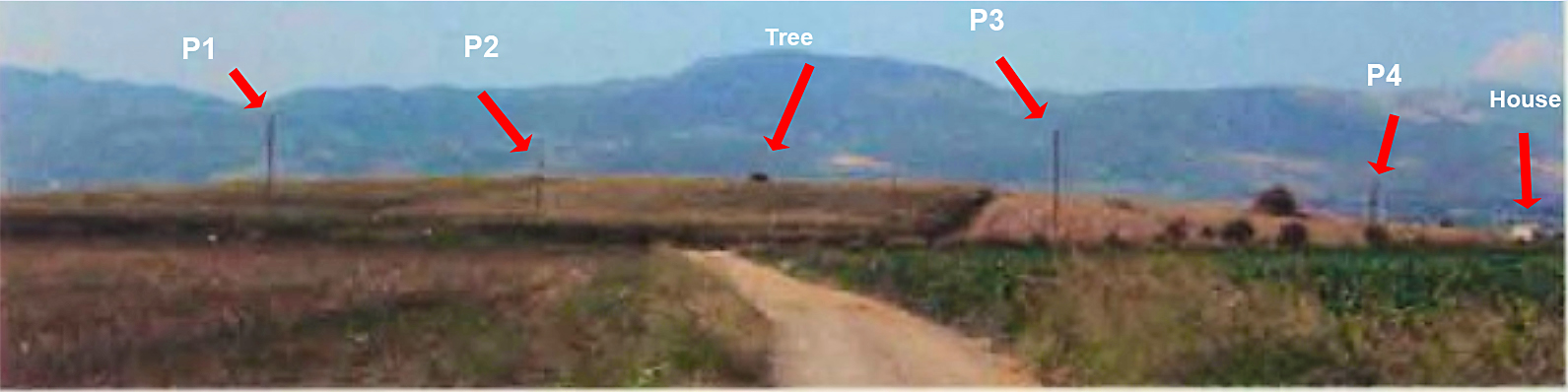
Ooof!  Not very good although I can tell you that it is much repaired over what it was.  Actually the photograph doesn't provide very much in the way of identifying information at all.  A mountain outline, a road, a rise, some telephone poles.  It's a kind of photographic haiku.

I went through, numbering the telephone poles and whatever other features I could pick out.  I took a good look at the outline of the mountain range to the N.  And I also took a very good look at that road in the foreground.  It might just be possible to find that road since we know what to look for.  Anyway, the result of my analysis produced this:


This shows the result of analysis.  I numbered the telephone poles from P1 to P4 and I was also able to identify a house at the extreme right edge and a tree growing on top of the magoula. 

Can we find those things in Google Earth?

I think so.  This is what I was able to do.


At the bottom center of this Google screen shot I put a push pin at the point from which I think the photograph was taken.  It's labelled 'Observer' and its coordinates are 38.594343  N, 22.750459 E.

If you want to follow this example you should get into Google Earth and try to find those telephone poles.  They're very hard to make out.  I may not have matched them up correctly but I think that they're correct.  The center of the magoula is at the blue marker.  I make it to be  38.595921° N, 22.750690° E.

O.k., you say.  'It looks like a rise in the ground but how do you know that there's really a rise there?  Maybe this is just normal fluctuation in Google Earth's representation?'

There's one last thing that we can do.  Google Earth provides a view shed feature.  From any point GE will indicate all the areas that can be seen from that point.  What happens when I invoke the view shed feature from the hypothetical observer's point of view?

I went ahead and did that and the results are as follows:


This is like the previous photo but with the view shed indicated in green.  Everything in green can be seen from the observer's view point which is at the bottom center of the screen.  Sure enough the rise in the foreground blocks out everything beyond until we reach the mountains.  Just as in Livieratou's photo with which you should compare this.

QED.

Updated 1/24/2018, evening.

If you look in the letters section you'll see that Anonymous encourages me to set the vertical exaggeration factor to 3 in order to magnify the vertical differences and make the smaller rises easier to spot.     Anonymous is right.  Manipulating the VE can often be incredibly helpful.   In fact I’m constantly going back and forth between 1 and 3 on the vertical exaggeration control.  But despite that I’m not convinced that setting the VE to 3 in this case gives us any unambiguous evidence.

Here’s a trick that I also like to use.

Click on the path control and then draw several path lines directly over the feature you’re trying to learn more about.  I show a path here that is an example of what I mean.  The location is the same as in the post, C1600.


The blue paddle here marks what I think is the center of the magoula.  Once you’ve drawn this multi-segment path put your mouse pointer on one of the segments and click on the right mouse button.  This will pop down a menu.  Click on the second choice from the end: ‘Show Elevation Profile’.


When you do that GE puts up a display that shows the heights for every point on the line.  


If the line you drew doubles back on itself the appearance of the elevation profile is vaguely periodic.  That just means that heights and depths are more strongly pronounced and seem to reflect each other.  It’s like taking slices out of the magoula.  You can quickly see where the high and low points are and how different they are from each other.  GE also shows you the maximum height; here 142 m. – and the low which is about 135 m.  This is a difference of seven m. or about 22 feet.   Sounds about right for our magoula.   It turns out that the high point is about where I thought it was.  Remember that the heights shown are only along the figure you drew.  It amounts to an elevation sampling.  

You might do this several different times with different paths before you decide what’s what.

You can also do this in GE with circles or just simple straight lines.  But I find that the multi-segment path is very useful.  This is a powerful technique and I urge all of you to experiment with it.

Mycenaean Atlas Project.

For the Mycenaean Atlas Project DB release 50 has been delivered.  It substantially completes the integration of some 400 sites whose locational information was furnished through the generosity of Dr. Alex Knodell of Carleton College.

If anyone has corrections, additions, doubts, etc. about anything on the website then please send them to bobconsoli 'at' gmail.com

Here at MAP we always want to hear from people.  Follow me on Twitter (@squinchpix) and on Google Plus (Robert Consoli).  Please do it.  I need your support!

Friends don't let friends use Facebook.


Notes

[1] The Innovative Geophysical Approaches for the Study of Early Agricultural Villages of Neolithic Thessaly whose website is here.

[2] Simpson [1981], 79.

[3] Livieratou [2006] 111.


Bibliography

Livieratou [2006]: Livieratou, Antonia   After the palace and before the polis: study cases from the centre and the periphery; The transition from the Late Bronze to the Early Iron Age in the Argolid and Central Greece (Phokis - East Lokris), Vol. 1, Dissertation for the Degree of Doctor of Philosophy, The University of Edinburgh, 2006.  It is online here.

Simpson[1981]: Simpson, Richard Hope. Mycenaean Greece. Park Ridge, New Jersey: Noyes Press, 1981.


Tuesday, September 26, 2017

Finding Prosilio

There has been a lot of excitement about the Chamber Tomb that was discovered in Boeotia near Orchomenos.  I didn't see the announcement until 9/26/17.  I was intrigued by it and set out to look for the site.

Orchomenos is here, on the western edge of what was the Lake of Copais in Boeotia.


The town sits on the eastern end of a long narrow ridge called 'Akontion' because of its resemblance to a spear.  (Here the vertical has been exaggerated.)  The little town of Prosilio, where the chamber tomb was found, sits on the south side of Akontion.  The arrow points to it.

How do we find out exactly where it was found? 

First I looked at the photograph here:


Photo by Yannis Galanakis,  Prosilio Excavation Project


Here's the crew working on what looks like the dromos to the chamber tomb (I'm not certain of this).

I guessed that here the crew is standing on the south side of Akontion and somewhere near Prosilio.  I then tried to recreate this photo in Google Earth.  Here's what I came up with:


The fact that I was able to confirm so many identifying characteristics in the photograph (how many do you recognize?) made me feel certain that I had found the right spot.  It is, in fact, the light-colored patch at the lower right.  Google Earth tells me that at this point I'm just 40 m. above the surface.  When we turn the view around we have this:


Here we're looking west towards the site which is the white patch in the upper center.

The actual site location is 38.501057 N, 22.932393 E       In the Mycenaean Atlas Project it is now C5011.

And just to put the icing on the cake it turns out that Google Street View is available for the road between the site and the light colored house.  Here it is:


The famous light colored house along with the identifiable tree.


Honestly I never get tired of doing this.  Google Earth is a lot more than just a set of maps.  

If you enjoy this kind of photo recreation of Mycenaean sites you might like this previous post where I locate a tholos tomb in Arcadia.


Please don't hesitate to write with reactions to this blog post.  I want to hear from you!

Follow me on Twitter:   @Squinchpix
...and on Google Plus: Robert Consoli

...and remember: Friends don't let friends do Facebook.


Friday, May 12, 2017

Confusion about the hill of Prophitis Ilias (C1926)


Gary: ‘Don’t confuse me any more than I am already.’
Little Darlings [1980]


On the hill of Prophitis Elias, in Boeotia, there is a LH house.  It is described in Simpson, Farinetti, and Fossey and these are just the sources that I happen to have to hand.

The problem is that there is disagreement about where this hill is.

1.   Simpson says
"The hill of Ayios Ilias is about 2 km. to northeast of Schimatari and to east of the road to Dilisi."[1]

2.   Fossey says
"The hill of Prophitis Elias, a rounded eminence, lies c. 4.5 km. South East of Skhimatari, a little to the North of the New National Road and overlooking the entrance to the valley which leads to Dhilesi."[2]

3.   Farinetti says  (I have broken up her quote in order to give letters to her choices)[3]

“The site of Prophitis Ilias has been given different locations in different gazetteers and reports on the site:”

A.   “- a hill 2km to NE of Schimatari according to Prehistoric gazetteers.”

B.   “- a hill SE of Schimatari (4km!) overlooking the valley leading to Dilesi by the chapel of Ag.Paraskevi (mentioned by Brown – the excavator) according to Fossey (1988: 57)”


C.   “- A hill 2km from A.Dimitrios, at Schimatari station, to the right of the direct road to Dilesi, much nearer to the sea (to the NE of the shrine of A.Paraskevi on hill) according to Brown (Brown BSA 1905/6: 93ff). The Brown location is probably the right one. He excavated a LH house (BSA 1905/6: 94-5). At the site material from other Prehistoric periods (Late Neo, EH, MH) has also been found (Prehistoric gazetteers: HS&D 1979; Syriopoulos 1968; French 1972).”

First of all let’s clear up some preliminaries.

The church of Ayios Dimitrios at Schimatari station is here: 38.322313° N, 23.610635° E (F954 in my catalog).

The church of Ayia Paraskevi is here: 38.332400° N, 23.627994° E.  It is not on a hill.

When Dr. Farinetti says "to the NE of the shrine of A.Paraskevi on hill" she implies that A. Paraskevi itself is on a hill.  While she plainly says that, her phrasing is ambiguous and she may not have meant that literally.  She may have meant this: "(Prophitis Ilias) is near the shrine of A. Paraskevi and is on a hill."   I choose to understand her in my rewritten sense.

What everyone seems to agree on is that Prophitis Ilias is on a hill and that that hill is … somewhere.

Simpson (Alternative 1 above) says that it is 2 km. NE of Schimatari.  That looks like this:


I think that this is unsatisfactory because there are no reasonable hills nearby.

Alternative 2 is Fossey’s description which I show in the next photo.  


Taken literally (that is, drawing a line exactly 135° (SE) of Schimatari) this gives us an unsatisfactory result.  For one thing it is on the wrong side of the highway.  There is a candidate hill which I have marked on the photo.  It does roughly conform to Fossey’s description of the position of Prophitis Ilias.  Before discussing that let’s next examine Farinetti’s descriptions.

Her choice ‘A’ is just Simpson’s description and we have already dismissed that.

Her choice ‘B’ is her report of Fossey’s description.

Her choice ‘C’ looks like this:


In this photo I colored orange the region which describes her choice C.  From this we see that her choice ‘C’ can be made to harmonize with Fossey’s description; these two descriptions ‘B’ and ‘C’ refer to the same place.

Here are our criteria:

a.    Rounded hill

b.   SE (or on the ‘right’ side) of the road to Dilesi from Schimatari

c.    Commands the entrance to the Dilesi valley.

d.   SE of Schimatari

e.    About 2 km. from Ayios Dimitrios at Schimatari Station.

f.     About 4.5 km. from Schimatari itself.

g.    Near the church of Ayia Paraskevi

What location simultaneously satisfies all these criteria?  Let’s look at this photo in which I drew in the constraint lines.


Yep.  All the lines seem to converge at one point and that is the hill that we've been discussing.  Does it command or dominate the entrance to the Dilesi valley?  I put together the following pano from Google Street View.  


Here we’re looking over about 150°.  The road up the hill looks directly west; on the other side of the pano you can see the mountains of Euboea across the gulf to the ENE.

Exactly as Fossey describes, it overlooks the entrance to the Dilesi valley as we see in the next photo.


So here’s what I think.  I say that the hill at C1926 is the hill of Prophitis Ilias (38.336267 N, 23.623502 E) and that's where the LH house site is.  I still don’t know where on the hill that house was found and so I have set my uncertainty radius at 200 m.  In the next photo I marked what I think is a church, perhaps even the church of Prophitis Ilias, but I’m not certain of that identification.  

(Updated on May 26, 2019.  I have been able to confirm that this church is, indeed, the church of Prophetes Ilias.)


So that's the best that I can do for now.  If any of my readers know better where Profitis Ilias is located I would very much like to hear.  Don't be shy.

~~~~~~~~~~~~~~~~~~~~~~~~~~~~~~~~~~~~~~~~~~~~~~~~~~

Status of the Mycenaean Atlas Project

Currently prototyping an alpha online version of the Atlas.  I'm probably about two months away from making it available.

I've recently added twenty-four locations in the area of the Skourta plain (Farinetti [2009]), some eighty points in and around central Athens (Mountjoy, [2005]), and about forty points in Cyprus (van Wijngaarden [2002]).

Anyone who would like to have a copy of the MAP database can send an e-mail to bobconsoli 'at' gmail.com or leave a comment on any of my posts.  

A large (about 2400 page) .pdf document which describes the entire database is available for the asking.

To run the MAP database requires a SQL server running on your desktop computer.   MySQL is such a server and it is powerful, industry-standard, and free.  

I can and will make .kml or .kmz files, which can be opened directly in Google Earth, available to those who would like them.  
I can also create .csv files for people who would like to import Mycenaean Atlas Project data into Google Earth but would like it in tabular form.
If you like these posts then please follow me on Twitter (Squinchpix) or on Google+   (Robert Consoli)

Facebook?  Sorry.I.just.can't. 


Footnotes

[1] Simpson [1981], ‘B 47 Schimatari: Ayios Ilias’, 52.  And in Simpson and Dickinson [1979] 'F 59 Schimatari: Ayios Ilias', 221.  As Fossey (p. 57, fn. 53) notices the original excavator got the name wrong.  Simpson and Dickinson follow this error.  It's 'Prophitis Ilias'.

[2] Fossey [1988], ‘5. Prophitis Elias’, 57. And see the additional bibliographic material at that place.

[3] Farinetti [2009], 11.  The relevant components are TA_51, TA_52, and TA_53.  The location of TA_55, a MH cemetery (I have called it C822), depends materially on getting the location of TA_53 correct.

Bibliography

Farinetti [2009]: Appendix I.14; The Tanagra plain and Eastern Boeotia in Farinetti, Emeri. Boeotian Landscapes; A GIS-based study for the reconstruction and interpretation of the archaeological datasets of ancient Boeotia. Faculty of Archaeology, Leiden University.  2009.

Fossey [1988]: Fossey, John M., Topography and Population of Ancient Boiotia, Ares publishers Inc., Chicago, Illinois.  1988.

Simpson [1981]: Simpson, Richard Hope. Mycenaean Greece. Park Ridge, New Jersey: Noyes Press, 1981.

Simpson and Dickinson [1979]:  Simpson, Richard Hope and O.T.P.K. Dickinson,  A Gazetteer of Aegean Civilization in the Bronze Age, Vol. I: The Mainland and the Islands, Paul Ã…ströms Förlag, Goteborg. 1979.

Blog Posts Concerning the Isthmian Wall

Since 2023 a number of posts concerning the Isthmian Wall and how we located its remaining segments, have appeared on this blog.  This post ...